|
CSI@SBC The report
Page1 KC2000 forum |
|
|
|
Author |
Topic |
Kelvyn
Advanced Member

Australia
184 Posts |
 Posted - 23/01/2012 :
5:27:01 PM Posted - 23/01/2012 :
5:27:01 PM 


|
Elsewhere [now
shown below] on this ( KC2000) forum is information about this
comprehensive, detailed analysis of all the material known
to date and which is pertinent to establishing the precise
location of the police camp site at Stringybark Creek.
Recently forum members were alerted to Mr Denheld's critique
of the team's CSI@SBC report (and his report offering a
different site location to that determined by the CSI@SBC
team).
A detailed review of Denheld's critique of the CSI@SBC
report, Whilst it is possible to detail numerous
inaccuracies, time would be wasted doing so as the team's
final published report is NOT the basis for Mr Denheld's
critique.
I forwarded the following email, December 24, 2011 to the
feedback email address
Mr Denheld
provides:
You are a very *disingeneous
person putting selected wording
from the CSI @ SBC Team's "K28" paper online to which you
have prefaced it with a photograph of the team's July 2011
report which has been released for general information. *(I
think he means dis-ingenuous)
You have used wording from an early DRAFT. Draft version K28
was a working version which was superceded by [many] further
drafts and culminating in the team's March 2010 report.
This report was provided only to Government
departments,agencies and other bodies with an interest in
the topic and was not released for general information.
Your claim that "in essence, the texts of subsequent versions are unchanged"
DOES NOT reflect the extensive material, including further
material, of the July 2011 published report.
( Yes but in the main the contents are the same. Bill )
So if this is how you provide objective comment and analysis
then it does little credit to your methods of analysis and
objective review of published material.
No doubt your way will be seen over time to be an amateurish
attempt to try to discredit the extensive and detailed
report, which draws upon ALL of the (currently) known
material concerning the question of the position of the
Police camp site at Stringybark Creek.
To give you just one example of your misleading and
inaccurate words:
YOU SAY:
"In the past I have been in touch with PROV and PHU
and neither have this sketch."
and you go on to quote from McMenomy.
Well, Mr Denheld you only have to look at the team's
published report to obtain a PRECISE reference to where this
sketch CAN BE FOUND in the records of the Public Records
Office. And isn't it interesting that it is within the
papers of the Crown Law Department !![See my note below
also]
The second very extensive diagram (drawn to scale and
annotated) prepared by McIntyre and reproduced in the team's
report was unknown until it was found in 2008 by M/s Liz
Marsden the Collections Manager, Victoria Police Museum &
Historical Services of the Victoria Police AND which first
went on public display, in August 2009, within the Victoria
Police Museum display, at the annual Ned Kelly weekend. You
may recall that on my return from the Kelly
weekend that I alerted the team to the diagram's existance
and shortly thereafter commenced to discuss, with Ms
Marsden, the issue of being able to examine it (and
reproduce it).
This I have been led to understand is not how you in the
past have
identified the method by which this document was discovered
(and by whom it was found) when it was the subject of an
article by Mr Paul Millar, -"Police map discovery takes
gloss off Ned Kelly", published in the Melbourne Age 12
September.
Mr Millar was first made aware of this diagram by me.
You can confirm how this diagram was found by reference to
the Journal of Australian Colonial History, Vol 13, 2011 in
which Ms Marsden's paper is at pp242 -248.
This diagram (THE ORIGINAL) is catalogued and held by the
Victoria Police Museum and NO copy of it is in any of the
"Kelly files" of the Public Records Office!!
Now IF YOU WERE TO DO AN OBJECTIVE story about this paper by
the team, I offer just one example:
Perhaps you would comment on other material therein such as
the extensive report of the Herald's reporter and how it
cannot be said that your claimed site fits the description
given by him (and which is confirmed by professional survey
of the country commissioned by the Team and the results of
which provide a profile of the land which matches precisely
to the description given by the Herald reporter).
You prefer to resort to the banal also: To quote you: "What
a lot of crap" .....; and "ars" - perhaps you meant "arse"
?)
And I do need to also reference your words when you refer to
the Team's identified camp site "This cannot be the site of
the shootout, in actual fact, gentlemen, like they say your
site [is] up the creek - truly."
Well, Actually our site is down the creek.
Yours is literally up the creek.
Suffice to say I am not going to waste any further of my
time continuing with words to show that you have done a
lousy job of being a critical reviewer of the report.
(
you can all read my critique document to which Kelvyn refers
http://www.ironicon.com.au/csi@sbc_bills_comments.pdf )
The report
(Kelvyn's csi@sbc report) is now in the public domain and I am sure it will
be seen to be an extensive, factually based report that is
very worthy of serious consideration and analysis by those
with an interest in the matter, and most importantly of
course by the authorities (both State and local) who will
ultimately decide the merits of the research undertaken by
the team.
Kelvyn Gill
[Recently - January 22nd 2012, I was made aware that in
Harry Nunn's Bushrangers A Pictorial History, First
published in 1980, at page 162, is McIntyre's diagram
credited as being Courtesy Public Records Office,
Victoria.]
Yes, I got a reply from Mr Denheld:
Very succinct in fact: "A Merry Xmas to you".
I still await a substantive reply to the matters I raised in
my email.
Oh, and as I indicated above I did send my email to Mr
Denheld's feedback address, so perhaps one day it might
appear therein on his web site but, as it is said - I won't
be holding my breath.
|
Edited by - Kelvyn on 22/05/2012 8:48:20 PM |
|
| |
|
Kelvyn
Advanced Member
Australia
184 Posts |
 Posted - 24/01/2012 :
9:29:31 PM Posted - 24/01/2012 :
9:29:31 PM
|
Oh my oh my.
How quickly a further few words from Bill Denheld have now
appeared (along with my email text above) on his feedback,
and
so that the record is maintained and as the words are
addressed to me (no copyright problem with this I assume)
here they are:
Thank
you Kelvyn Gill. For someone who has such mastery of the
English language, it's a pity your 'team's book, CSI@SBC did
not take into account all the evidence on the ground at
Stringybark Ck, such as Two old fireplaces, a Slope, the
early newspaper illustrations of the scene of the 'murders',
the Orientation of the Burman photo which is looking South
-not North - (you silly fellows) and then your team decided
on a site that displays no such crucially important markers
as mentioned above. Dear Kelvyn, please take a look at this
photo (link below) where in you stand on the road with other
team members. It was the day I pointed out there was no
slope comparable to the Burman photo near the Kelly tree.
Bill
http://ironicon.com.au/twohuts/images/northviewnearkellytreesite.jpg
My oh my, same stuff different day.
Read the team's report and consider ALL the evidentiary
material therein.
The conclusion is obvious from that material and will stand
all rigourous scrutiny applied, and will be used as
necessary by me, and I am sure others, to see that the
appropriate marking of the sight - when the appropriate
authorities elect to do so (if indeed they do) are placed
appropriately.
And for the sake of absolute correctness, also now shown on
Mr Denheld's site is the full text of a letter to him on the
20 March, 2010, signed by Linton Briggs (and I stress with
the endorsement of myself, Gary Dean and Glenn Standing -
the team members):
Dear Bill,
We agreed recently that I should seek feed back from Kelvyn,
Gary and Glen about your case for the police campsite on the
western bank at your two-hut site which you earlier sent
around the group for consideration.
They have responded, and confirm they are confident that
exhaustive review of all the available evidence places the
campsite further north on the eastern bank, as concluded by
the investigation draft report, with which you are familiar.
This does not mean to say the case you have developed is not
worthy of consideration and assessment by Heritage Victoria
and other interested parties. On the contrary, I at least
have found your case to be both stimulating and productive
in the sense it has made the group look more closely at some
aspects of the development of the other proposal. In fact,
by looking more closely, the study has been considerably
strengthened in places.
One example has been the search for and inclusion in the
latest version of the study, reference relating to
establishing the camp on the Stringybark Creek at the burnt
hut. ….”which took us to the old diggings, at the burn hut
on the Stringybark Creek”, further clarifying there were two
huts, one burnt the remains of which were apparent, the
other, still standing in the bush outside the campsite
clearing. (Kenneally, Wilson Hall, Ned)
Another example relates to the rising terrain in the
background of the Burman photographs, the most important
topographical feature which I understand leads you to
conclude the Burman photographs were taken from a position
facing south, orienting the police camp at your two-hut
site. We have included an additional appendix (Heritage
Victoria diagram 2205), a contour map of the precinct, and
additional commentary which demonstrates the rising
background at both the proposed campsites to be remarkably
similar. The 1897 Beautiful Mansfield (burl tree) photograph
at 4.2.1 viewed together with the contour map reveals the
background terrain to be rising from the creek bed to the
eastern skyline, a height of about 30 metres, over a
distance of about 340 metres. At your two-hut site, looking
to the southwest, the degree of slope is almost identical.
The study’s report commentary at 4.2.1 has been amended to
now read, in part:
4th paragraph: Timber harvesting and ring barking since 1878
reduced vegetation density revealing background Stringybark
Creek topography rising about 30 metres east south east to
the eastern bank tableland elevation. This landscape feature
is also discernable in the Cuddon photograph below at 4.2.3
and in the foreshortened Burman photograph plate 1 at 4.3,
photograph number 4.
Appendix 13 is the map used by Heritage Victoria to indicate
the land (marked at L1 on diagram 2205), placed on the
Victorian Heritage Victorian Register in 2009. This map
shows ground surface contours at 10 metre intervals. From
Stringybark Creek opposite the police camp position
(elevation under 770 metres) the ground rises towards the
east south east to 800 plus metres over a distance of about
340 metres.
Incidentally, a blow up of photograph no. 1 confirms the
existence of a burl on the trunk of the tree in question, –
not just a bunch of leaves.
The group again confirms it remains strongly of the opinion
the two Burman photographs were taken from the western bank,
looking respectively to the east and east south east. The
group submits the rising background of photograph no 1 is
the same background portrayed by the Burman photographs.
The group acknowledges your tremendous drive and effort to
initially help bring a team together in order to challenge
the conventional wisdom of the day about the authentic
campsite location.
It brought together a group of dedicated people, united in a
common purpose.
The group has noted your advice to me you could no longer
remain a member of the team putting forward a proposal the
police camp was located near the present day Kelly Tree, but
that you would like your case to be presented to Heritage
Victoria for consideration. The group advises it is
supportive of this course of action, in the interest of
providing Heritage Victoria with an opportunity to add
rigour to their assessment by evaluating another proposal.
The group feels that this would best be actioned through
yourself independently lodging your case with Heritage
Victoria. Accordingly, as discussed with you, I have
drafted, for consideration by the team, the following
paragraph for inclusion in the report’s introduction:
“Mr. Bill Denheld, a former member of the investigating
team, agrees that the authentic location of the 1878 police
camp is sited on the western bank of Stringybark Creek, but
that it was established at a site 274 metres south of the
present day Kelly Tree. Mr. Denheld advises that he has
developed a case which he will submit to Heritage Victoria
for consideration.”
When Kelvyn is able to produce a final version of the report
for lodgement with Heritage Victoria,
I will see that a copy will also be provided to you.
I will give you a ring some time next week to talk through
the above.
Kind regards, Linton Briggs
And the succinct rebuttal shown following the letter's
transcript:
Seems the quest for rigor in the debate for the true site
at SBC has been replaced by inflexible false beliefs based
upon too much literal evaluation.
Tit for tat is simply a waste of time.
I am reminded of the words from The Time Warp*
Its just a jump to the left
And then a step to the right,
seems appropriate to the matter.
sine die
and for a bit of a jape:
Question: What meaning or purpose did the artist wish to
convey by including the axe in his sketch?? (Look carefully
its embedded into a stump!!
*Rocky Horror Show.
|
 |
|
Kelvyn
Advanced Member
Australia
184 Posts |
Posted - 27/04/2012 :
7:49:33 PM
|
And now another piece
of the puzzle has been completed and is on display for all
to see at Stringybark Creek.
The spring(s) are again now active following the rains over
the past couple of years (following drought times) meaning
the underground is now fully saturated, particularly with
the rains of the last month or so.
Two springs are there for all to see.
Both where we said they should be in our CSI@SBC report.
One spring is on the road reserve - small water flow; the
other to the west of the camp site with a significant water
area.
The swampy corridor also discussed in the report is indeed
just that at present and spear grass is growing profusely in
this corridor. Clumps now approaching 5 feet high are there.
A visit to the two rock piles to the South of the police
camp site did not result in any trace of a spring being
found (Oh, I forgot, of course Stringybark Creek is the
spring!!)
And, my word, there has been some activity in the vicinity
of the rockpiles. Various coloured markers seem to be placed
throughout the area.
Are we in for another hypothesis about this site??
( As said before, Stringybark Creek is the 'Spring',
not the
trickle from a higher level remnant of a swamp when it rains. Bill)
|
|
|
|
Kelvyn
Advanced Member
Australia
184 Posts |
Posted - 22/05/2012 :
8:47:20 PM
|
For those who have not
obtained a copy of the report by the CSI@SBC team (the
profit from which is being donated to the Glenrowan
Improvers committee) the details are:
'C.S.I. @ S.B.C.’
AN INVESTIGATION TO REVIEW AND EVALUATE THE EVIDENCE TO
ESTABLISH THE AUTHENTIC LOCATION OF THE POLICE CAMP SITE AT
STRINGYBARK CREEK
____________________________________
THE VICTORIA POLICE EXPEDITION AND THE ENCOUNTER WITH THE
KELLY BROTHERS AND THEIR ASSOCIATES AT STRINGYBARK CREEK,
NORTH EASTERN VICTORIA,OCTOBER 25 – 26, 1878.
_____________________________
FINDINGS,CONCLUSIONS AND RECOMMENDATIONS OF THE
INVESTIGATION TEAM:
LINTON BRIGGS
GARY J DEAN F.A.I.H.A
KELVYN GILL
GLENN STANDING
________________
JULY 2011 Second edition. This paper was first released
March 2010.
Publisher: Glen Rowan Cobb & Co. Pty. Ltd.
37 Gladstone, Street, Glenrowan. Victoria. 3675
Printed in Australia by Think Print Wangaratta, Victoria
ISBN: 978-0-646-55998-8
The report is available by contacting Gary Dean: tel: (03)
57662409
or
email:
gdean@nedkellysworld.com.au
|
|
|
|
poorflower
Senior Member

Australia
48 Posts
|
Posted - 29/05/2012 :
11:30:03 AM
|
Please wait I need to
edit this text, and will be adding more information
PF
In August of 2010, I posed a question to Bill Denhold, about
the tilted trees at his site,
The trees at his site tilt the wrong way
Where are your tilted trees, to match the Burman
photographs.
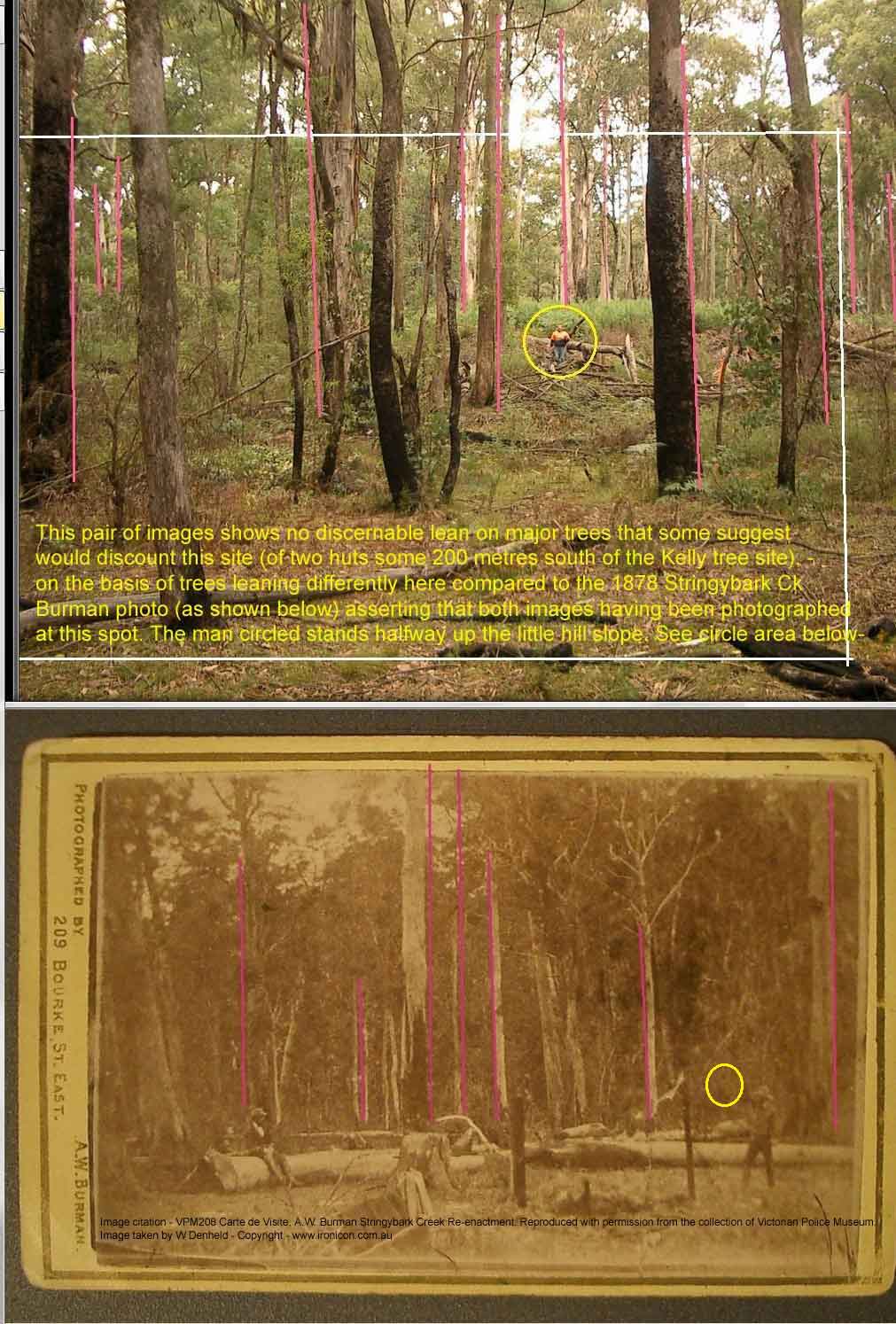
My critique,
Poorflower, you have exaggerated the lean
of your pink poles over these images above.
Regarding these images you have used,
you should edit all your
postings and include the following citation on the Burman
photo,-
" Original Image - VPM208 Carte
de Visite, A.W. Burman Stringybark Creek Re-enactment
.
Reproduced with permission from the collection of Victorian
Police.
Image courtesy Bill Denheld ironicon.com.au -
This citation had
been agreed to with the Victorian Police Museum (VPM)
where this original (upper) Burman photo was
photographed by me. I do not own this
historic
photo (copy as shown), I have permission from the VPM to use this image.
Wherever you use this Burman photo please insert this
citation
as
above.
If
this is not done the KC2000 forum owner will be seen as
contravening the VPM requirements.
Lets examine your pink lined posted pictures.
|
The old tree to the far left ( Upper picture but hard to see
as the image is small) most probably has a
lean to the left due to old age and root erosion
because this is where the bank of the creek starts to lower, and
where most of the trees are near vertical.
However you raised this 'Lean' as a reasonable question to which I gave
my best answer at the time that my camera has a fault that
shows a slight lean in
all my bush pictures, BUT then shortly after my explanation you
deleted all your postings from the original SBC News and
Views forum page, and I was puzzled by this because 'the forum
admin' would have been dead against this deletion. Why then would
'a
school girl as you claim to be', and now with babe, be so
interested in this Ned Kelly history, and want to delete these
technical issues on a major Ned Kelly Forum that your
science teacher instigated, and then your obvious keen interest to denigrate
only my
research? This is not what a school girl expecting a baby would be
interested in doing?
Because I sensed Poorflower was not what she was said to be,
and shortly after her
postings were deleted from the SBC news thread, that's why I
uploaded copies of the debate 'out of respect' for
all those that were taking part. Then why is
Poorflower now
raising the same questions aimed at me when she knows I have
not been able to reply on that forum? Secondly, according to Bruce (admin)
it was Poorflower that deleted her postings, yet Poorflower
then created another thread titled "The Gloves are Off Denhold"
( now deleted from KC2000) So why would a school girl be so antagonistic towards me saying the gloves are off Denhold-
meaning by her things will get dirty? You don't even spell
peoples names properly'
I will prove to the readers that your arguments
are as hollow as your identity.
Poorflower, you are one of the people behind the 'CSI@SBC Report ' pretending to be a school girl when all you want to
do is denigrate the only positive scenario that stacks up in
every way, that is my document concerning the site of two
huts. Whoever you are, you are trying to cover up your mis informed notion that the police camp was near the Kelly
tree as proposed by Linton Briggs and those that fell for it.
How do I come to this conclusion?
You have copied one of the pictures from my photo files that I gave
to Kelvyn Gill and Glenn Standing
for the purpose of the document we were collaborating to
release. How can it be that Poorflower can use a photo from my photo file and doctor it to
show exaggerated lean angles of trees at the two huts
site - (the true site). Poorflower thought that by comparing leaning wind
swept saplings, that this would swing the argument away from
the two huts site, and towards the Kelly tree site.
I add these
pictures and notes below -
This image below shows
where Poorflower cropped to the (white line) from the whole image and
deleted the figure circled, in your slanted version above.
This is one of my pictures no one else had access to except Kelvyn or Glenn.
|
|
Both pictures were taken by me and no one has asked
their use from
me.
The two pictures depict the true scene
showing most mature trees as near vertical in both photos.
Certainly not how Poorflower wants to portray it.
If there is any skew in the images this will be due to
camera
distortions resulting from lens relating to glass photo plate or
digital photo planes. These distortions were adjustable in
early
wooden box cameras but now with digital cameras the
focal plane is set - but not always dead on square to the
lens which skews the image left or right -as in the case of
my small credit card size camera.
If we were to add pink poles to this image below, (said to
be supplied by Glenn Standing of the Kelly tree site),
clearly then
the ground angles are all wrong if the Burman photo is to be
the model template, it does not match as Poorflower 16 days
after this posting informs us ? |
Edited by - poorflower on 29/05/2012 12:04:12 PM |
| |
|
|
|
mace
Advanced Member
Australia
62 Posts
|
Posted - 29/05/2012 : 12:38:28 PM
|
Mixed species forests,
such as around SBC are dynamic things. Forest areas on our
property, similar elevation, 8k in a direct line to the
east, has changed markedly in age and composition. Even in
my lifetime, I walk into small pockets of timber that now
look nothing like they did when I was young (40 years ago).
IMO its ok to compare photo's (in mixed species forests)
that are say 30 years apart, but very hard to make valid
comparisons with photo's that are say 50 to 80 years apart.
Young trees become mature, mature trees become senescent.
Composition, structure and lean for example, get altered by
available light. They are growing, vibrant plants, all
plants adapt and change to suite their environment in this
way.
The SBC Report has provided linkages via photographic images
in and around the current Kelly Tree from the 1890's thru
the 1930's to the present day. Ive studied them carefully,
Im still making my mind up as to their validity, but on
first impressioons there are some reasonable assumptions
made.
As a comment, Ive spent (in a previous working life) 20
years in production forestry and Natural Resource Management
in this area and have seen forest composition change
markedly in response to fire, logging and possible even
climate change. I think that direct comparisons of modern
images of vegetation with ones over 100 years old without
any linkage images is questionable.
Regards, Al. |
Edited by - mace on 29/05/2012 12:39:08 PM |
|
|
|
Trent
Advanced Member
Australia
94 Posts
|
Posted - 29/05/2012 : 1:00:17 PM
|
Hi all well said mace
I have lived in the dandenong ranges all my life some places
are completely different to what they were 30 years ago and
I am talking about right out in the bush up here. I have a
creek running through the property which has changed course
in 9years and springs up here can change from year to year.
With logging and bush fires for which I am sure SBC hasn't
escaped in the last century even the terrain would have
changed a little. This is just my opinion as I have lived
and camped in the bush in the same places most of my life
and the changes that I have seen whether man made or natural
astounds me.
Cheers Trent |
|
|
|
Kelvyn
Advanced Member
Australia
184 Posts |
|
poorflower
Senior Member
Australia
48 Posts
|
Posted - 05/06/2012 :
10:18:09 AM
|
On the 02/08/2010 I
wrote
"Trees grow mainly towards the sun or the most sunlight,
they also grow against gravity, they also grow towards
vertical against the angle of a hill."
After the tilt in the trees at his site was pointed out to
him as being the wrong direction,
Denhold came back with an excuse that his camera was faulty
Denhold said
"Hello All,
I am afraid my digital camera that took the image is at
fault.
I had noticed quite some time ago that there was a lean to
the right of the trees in all my recent shots"
YA RIGHT DENHOLD
Photo's from other camera's show the same tilt.
The sun has not changed position since 1880, the trees still
grow the same.
Taken from forum, 3/08/10
"Plants tilt Due to plant growth hormone, call auxins
Plants in nature have the ability to balance the presence of
auxins in plant parts either in root tissue or shoot tissue.
At the same time auxins has negative effect against light.
Less auxins is detected on the side of the stems/branches
facing the light source and this will slowed down the growth
on this side of the stem, while the shadowed side, which
contain higher concentration of auxins will grow faster.
The uneven growth rate of the stem/branch will cause the
plant to bend and growing towards the sun, and not
perpendicular to the surface of the earth where the plant is
growing. IE hill."
You can still see that the tress tilt towards the sun, today
some 130 years later, photo by KC200 I think.
There are no tilting trees at the Kelly tree that match the
same tilt as the burman photo.
PF |
Edited by - poorflower on 05/06/2012 10:21:50 AM |
|
|
|
poorflower
Senior Member
Australia
48 Posts
|
|
poorflower
Senior Member
Australia
48 Posts
|
|
poorflower
Senior Member
Australia
48 Posts
|
|
Glenn Standing
Advanced Member
Australia
72 Posts
|
Posted - 05/06/2012 :
9:54:16 PM
|
Hello Poorflower.
You have put a great deal of thought into your posting and I
thank you for it.
I’ll do my best to answer your questions.
Regarding the direction of the sun. On page 78 of the
CSI@SBC report there is detailed the sun movement across the
police camp site as it would have been on the 3rd November
1878. Obtained from Geoscience Australia. The angle and
direction of the sun is close but not exactly the same today
as it was then.
The sun direction came from the NE at 9am through to the W
at 6.30pm.
At say 1pm the sun direction was NW.
(Azimuth 324deg. 08’ 38”) (Altitude 64deg. 15’ 36”)
The images taken recently near the Kelly were taken when the
sun was coming from the NW at approx. 1pm.-1.30pm. Guess
best described as coming from near the bottom left hand
corner of the images posted on the SBC thread. One of which
you have shown above.
So why then aren’t all the trees leaning to the NW? Some are
some aren’t.
According to your suggested theory they all should lean
towards the sun.
When obviously they all don’t.
As to the width of the photo/site. Sorry, I did not measure
the width of the site/ image. So without making another trip
up SBC to do so I cannot accurately say. The images were not
meant to be an exact replica of the Burman image/images. But
taken to demonstrate that there is in fact a suitable slope
in the background, a flat foreground and light in the trees.
Very similar to the Burman images.
If you were to draw an imaginary outline of the E/W log on
the photo you would still be able to see some distance
behind that log. You would still see the people near the
Kelly tree, or any smaller logs that might be lying on the
ground. So there may or may not have been raised ground
behind the E/W log in the Burman images. Regardless. The
smaller logs would still be seen. I think your last image
demonstrates this quite clearly.
Hope all this helps.
Best regards,
Glenn
|
|
|
|
Thomas McIntyre
Advanced Member
51 Posts |
Posted - 15/06/2012 :
3:15:48 PM
|
Mr Duncs. Thank you
for the comments recently made by yourself at another place
here within this forum - Stringybark Creek news and views if
my memory serves me right.
Yes, indeed your observations are very pertinent and I
assume you have had the opportunity to read and critically
analyse the work of the team who prepared the report by the
moniker of CSI@SBC.
I believe I was recently appraised that this matter will be
subject to a magic lantern show in that wonderful town of
Beechworth during the early part of August.
I do hope to be an interested observer at such.
One thing I do have often is time on my hands these days
once I peruse the daily broadsheets and partake of
consideration of some of the topics being canvassed within
this forum.
Good cheer to you Mr Duncs. |
|
|
|
poorflower
Senior Member
Australia
48 Posts
|
Posted - 22/06/2012 :
12:56:00 PM
|
Hello
called into SBC recently but the weather was too prohibitive
to do much work, looking around the area there are signs of
some activity, full of under growth and the leeches are
hungry.
The reason for going to SBC was to check some more trees
with a plumb bob,
what I am trying to point out, is the sun travels from the
tropic of Capricorn to the tropic of Cancer, trees will grow
towards the most sun, trees will not suddenly jump around
and start growing away from the sun.
What reports are there of fires being right at the Kelly
tree?
apart from what the DNRE lit.
I have made a model of the trees in the forest which
demonstrates this principle of trees growing towards the
sun, this is all about the orientation of the the Burman
camera to the tilt of the trees, the Burman photograph is an
11 mts or 36 foot wide snap shot of the forest, which
clearly shows the very large old tress tilting .
As you rotate the model it produces some very interesting
results
and blows away the denhold claim, to see near vertical trees
you must be holding the model and be looking either almost
North or South,
when you start to move away from those directions you
immediately start seeing the tilt.
PF
Another thing I have just noticed is the ground in your
photgraph slopes to the right.
Poorflower, This tree lean argument is very hollow.
Here is what I found on the internet
'Why do trees grow straight ' ?
Scientific American has to say on the subject
Quote from above webpage
" A plant on a windowsill experiences a stronger
light gradient than does a tree outdoors, where
gravitational cues can overpower more subtle
light-direction cues. Indoor plants get a lot more
light on one side than on the other, which activates
photoreceptor
molecules to a much greater extent on the lit side.
This difference is biochemically translated as a
growth response, known as phototropism,
which makes the plant bend toward the light.
Trees growing at a latitude of,
say, 60 degrees ( further to the south near the south
pole) are also asymmetrically illuminated because of
the slant of the noon sun—approximately 55 degrees at
the beginning of the summer growth season—but the
difference in light intensity there is smaller and
more variable. The modest light gradient experienced
by the tree is counteracted by a continuous
gravitational influence, known as gravitropism,
which guides plant growth upward.
The strength
of gravitropism
trumps phototropism in the tree scenario but not on
the windowsill. The edge of forest gaps provides a
good place to observe light-guided tree growth at any
latitude. There the effect of a strong light gradient
can be seen in the reaching of trees into the gap."
To which someone
writes - Keith Labreque 5/8/2009
Quote "The relevance to the
topic is that because the earth spins at a very high
surface speed, one would think that at a
mid-latitude of perhaps 45 degrees the centripetal
acceleration would alter the direction of apparent
gravity noticeably. It does not, however, because in
reality the centripetal acceleration is miniscule
compared with local gravity. So although
plumb bobs there don't hang vertically, and trees
there don't grow vertically, the effect is so small
you cannot observe it.
"
My
comment,
This debate about photos of leaning trees at Stringybark Creek can be dismissed as irrelevant.
Photographic camera distortion, and the will of the
photographer to create a balanced composition,
i.e., unlevel ground verses upright trees will
always be a challenge.
Plumb bob exercises? I would assert that even with
accurate laser pointing
apparatuses set on stable level tripod to gauge
the lean of
a tree or trees SBC, would show insufficient lean in a
general sense except for young trees growing on the edge of a clearing
as the professor said,
"
The edge of forest gaps
provides a good place to observe light-guided tree
growth at any latitude. There the effect of a strong
light gradient can be seen in the reaching of trees
into the gap."
We
have to remember when Burman took the photo, all the
mature trees were part of an undisturbed forest around that time,
and before any
part had been cleared, and no trees would have
developed a lean during the short time period
since the clearing there. We can be pretty sure the lean
of any trees at the Burman photo spot were leaning
left or right and every which way according to the
'then' forest canopy and that no
particular pattern could be attributed to the effect
of the sun arcing through our northern sky.
Therefore, to try to determine where the police camp
was by testing the lean on mature trees in photos
and current circumstances is not a viable theory.
Examples of cameras that can correct for
parallel distortion.
Burman's
camera was earlier than this one below, but the principle of
bellows allows for correction of what would be
vertical walls or trees as in Burman's scene of
SBC to be seen as vertical structures that would
otherwise appear to be leaning inwards.
Modern digital cameras generally don't
have such features except for very expensive ones that have
higher quality lenses specifically designed to
reduce distortions such as for photographing
buildings and to keep straight lines straight. These
days with digital photography, distortional
correction can be done easily with computer
software.
Example of early
cameras from Google images.
.jpg) |
 |
|
.jpg)
This image shows
a typical correction of parallel distortion.
Burman would have done the same corrections when
taking his shots at Stringybark Creek, so the
photo looked right. |
 |
This camera left was more like the type Burman
would have used and was a simple version of the
later compact cameras shown above.
The function still allowed parallel distortion
to be minimised with the sliding hinged mounted
lens.
|
 |
Poorflower,
More important to your argument is the angle of vertical
trees to the ground.
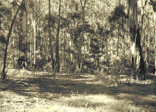
In this posting you say -"Another thing I have just noticed is the ground in
your photgraph slopes to the right."
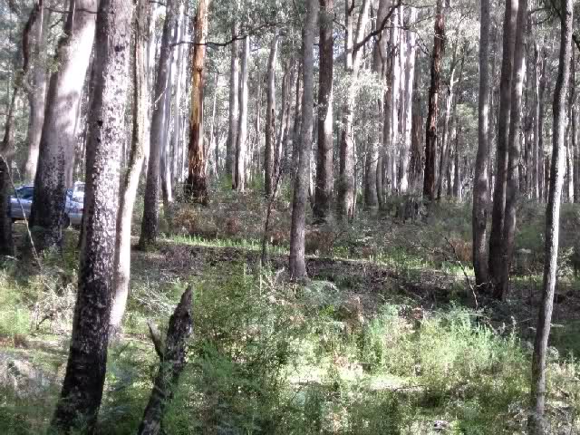
This is Glenn Standings picture of the Kelly tree area,
( not mine)
and yes I agree if you compare this landscape with the
Burman photo the ground slopes the wrong way. Nothing
anyone can do about that though.
This in its self should raise concern for the proponent
authors of CSI@SBC
as we cannot change ground levels to suit an argument.
On this basis alone the Kelly tree site cannot be
compared with the Burman photos. Bill Denheld |
|
|
Edited by - poorflower on 22/06/2012 1:19:09 PM |
|
|
|
poorflower
Senior Member
Australia
48 Posts
|
|
Glenn Standing
Advanced Member
Australia
72 Posts
|
|
mace
Advanced Member
Australia
62 Posts
|
|
Kelvyn
Advanced Member
Australia
184 Posts |
Posted - 18/07/2012 :
4:30:18 PM
|
The CSI@SBC team will
be presenting at the Beechworth Kelly 2012 Ned Kelly
Weekend their extensive & exhaustive review of ALL
the available contemporaneous information; explaining their
detailed field work and the results of the survey by
professional surveyors.
Since the team's report was published in July 2011
(ISBN:978-0-646-55998-8)* some further material has been
"discovered" and this will be discussed also.
Sunday 5th August at 9.30am, Beechworth Town Hall.
The team looks forward to meeting people with an interest in
this topic, and talking about their work over a quiet ale or
two during the weekend.
* Available on the day for purchase.
e |
|
|
|
poorflower
Senior Member
Australia
48 Posts
|
Posted - 20/07/2012 :
12:25:13 PM
|
To the members of the
CSI@SBC team
the way I see this is it all boils down to this.
When you all stand up in front of the crowd at Beechworth in
a few weeks they will all be expecting to see conclusive
photographic evidence of the Police Camp Site, that match's
photo A, its as simple as that.
If you cannot do this then what the outcome for you is in
the lap of the Gods
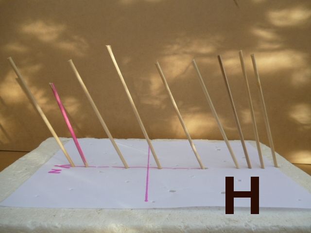
when I finish here I hope to demonstrate to you what the
audience will be asking, and can be demonstrated with a
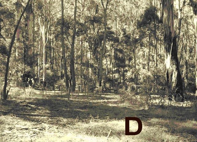
simple model, shown in photo H, based on photo A, whether
the model is in 1D or 2D or 3d does not matter the results
are the same, this is all about the camera angle and tree
growth.
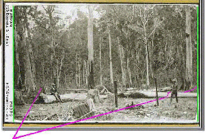
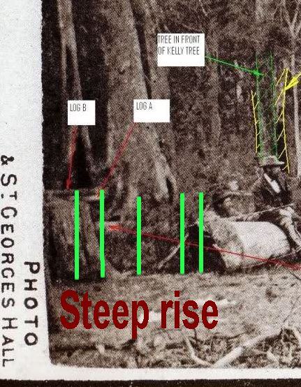
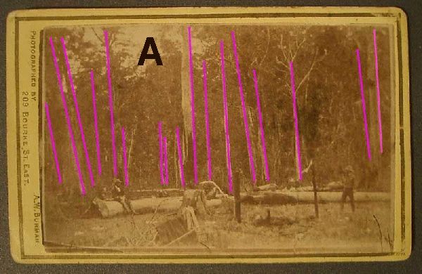
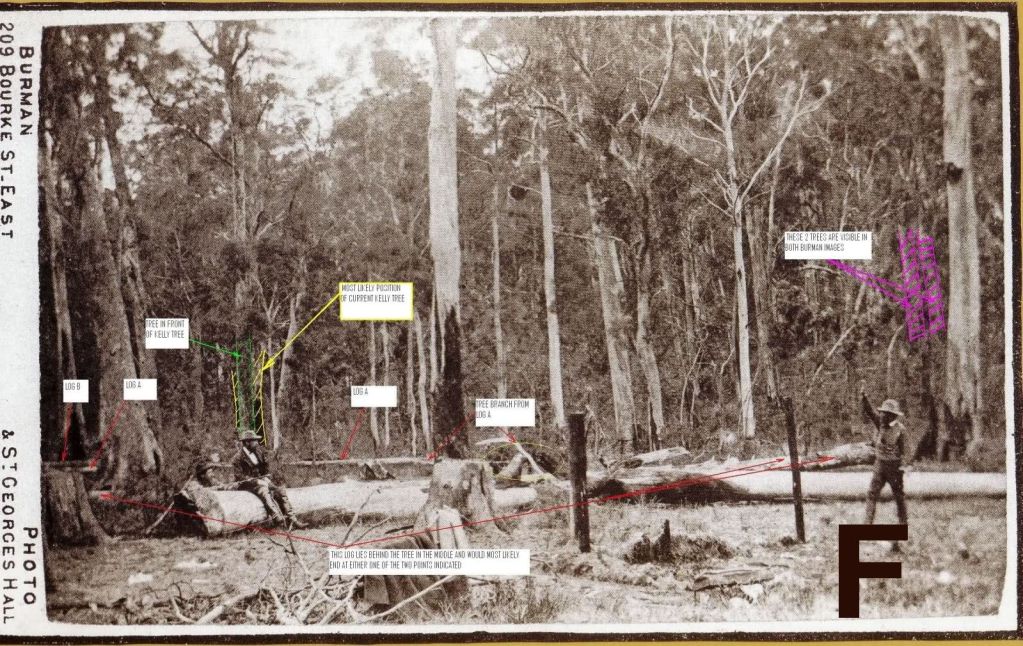
Lets look at photo A, it shows tilting trees pointing to the
Left
the actual compass direction does not matter.
Also there is a steep step up on the left of the picture
behind the two men.
I may not finish this today
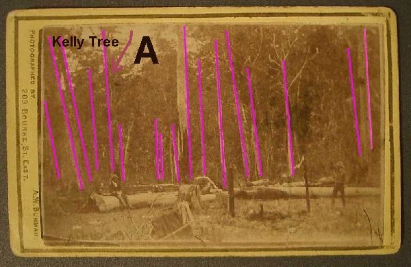
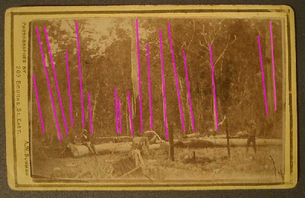
" Original Image - VPM208 Carte
de Visite, A.W. Burman Stringybark Creek Re-enactment
.Reproduced with permission
from the collection of Victorian
Police.
Image courtesy Bill Denheld ironicon.com.au -
( NOTE, the pink lines and Text has been added by
'Poorflower')
You are saying the present day kelly tree is shown here in
picture A
|
|
Edited by - poorflower on 21/07/2012 11:31:47 AM |
|
|
|
poorflower
Senior Member
Australia
48 Posts
|
|
poorflower
Senior Member
Australia
48 Posts
|
Posted - 20/07/2012 :
12:27:17 PM
|
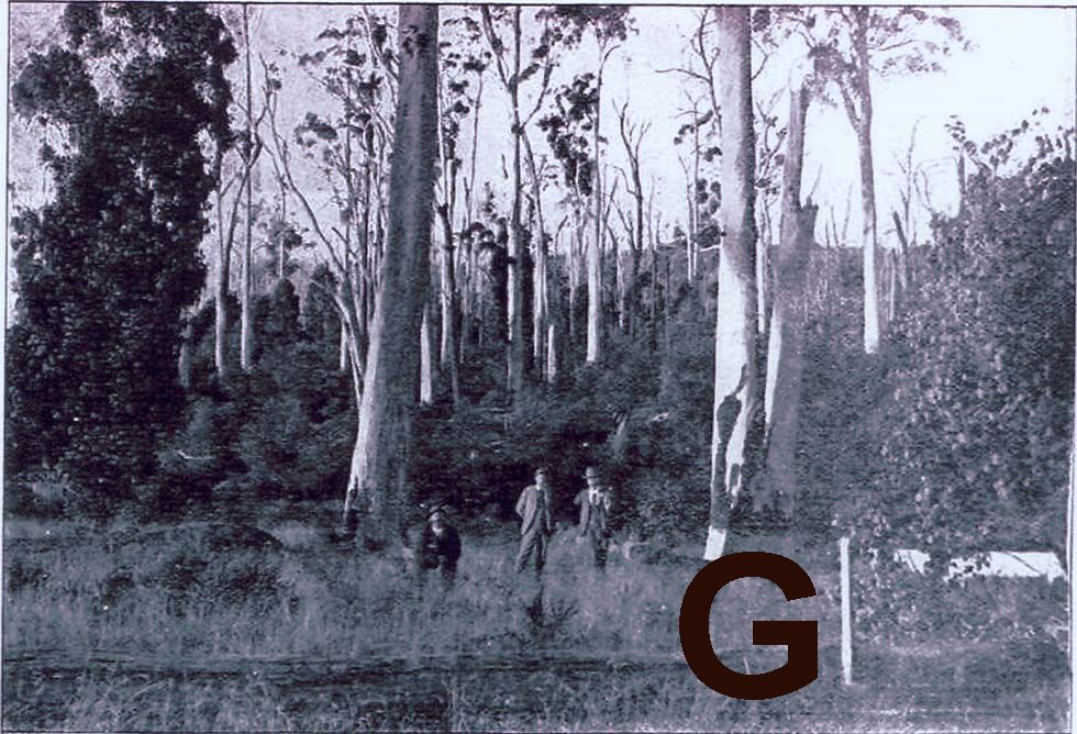
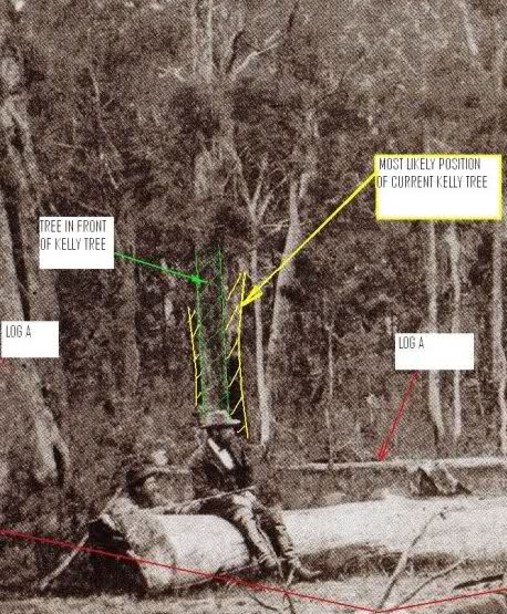
From the CSI@SBC
report this photo was taken in 1938,
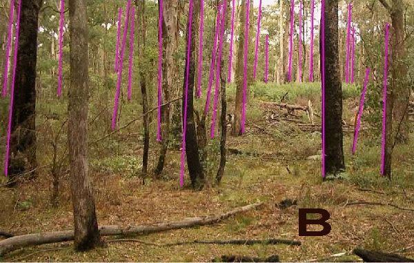
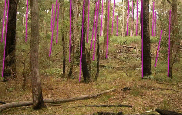
When we compare this photo with photo A the tilt is
the wrong way, how can the tree in the back
left be the present day Kelly tree.
Yes the sun appears to be coming from the left of the
photo, but the point is why have the the tress tilted
180' from photo A, in only 58 years, we have gone from
a left tilt to a right tilt, really the only answer is
its not the same scene as in photo A.
Citation,
Mr Cuddon Image courtesy of the Engelke family in WA

" Original Image - VPM208 Carte
de Visite, A.W. Burman Stringybark Creek Re-enactment
.
Reproduced with permission from the collection of Victorian
Police.
Image courtesy Bill Denheld ironicon.com.au -
(
NOTE, the pink lines and Text has been added by
'Poorflower')
Please
note; The inclusion over this image above of
CSI@SBC
is a breach of
copyright as this infers the image belongs to the proponents
of csi@sbc, and therefore Poorflower may be one of them.
Poorflower, please make sure to replace this image
you have marked 'A' without csi@sbc
and see that all my images used are properly cited on the
KC2000 forum pages. Bill |
Edited by - poorflower on 21/07/2012 11:39:42 AM |
|
|
|
poorflower
Senior Member
Australia
48 Posts
|
|
poorflower
Senior Member
Australia
48 Posts
|
|
poorflower
Senior Member
Australia
48 Posts
|
|
poorflower
Senior Member
Australia
48 Posts
|
|
|
|
Please Note,
This was only page 1 but decided not to continue to show page 2.
Since this csi@sbc The Report - a KC2000 forum page thread Copy has been
shown here at Iron- Icon, the original forum thread at KC2000 has been
heavily edited by deletion of all images, however, the pictures that remain
still don't have proper image citations added as was requested.
They still breach Police Historical Museum (PHM) and copyright .
All images that Poorflower had used in his/her argument to determine the
proper site of the 1878 Police camp have been deleted, compromising the
whole KC2000 forum thread, therefore one wonders who Poorflower really
is?
In conclusion, I have decided to restore all the images on this page so
the reader ( you) can make sense of this interesting debate, one from
which I was excluded by the administrator. It's a pity many grown up
people cannot demonstrate a common courtesy when they decide to enter
into a public debate.
Oh, I almost forgot, trees do grow straight to counter balance the pull
of gravity, otherwise they will fall over. Trees do lean out from the
edge of a forest towards the light, or lean over where the ground on
which the tree grows subsides as on a steep creek bank, but in general
all trees do grow straight up.
Any pictures showing leaning trees is more likely the result of the
photographer taking the ground as level and as a priority, and
compromising the ground to tree 'angles' which may give the impression
of leaning trees. Then there is also camera lens distortion which makes
trees or vertical buildings look like they are leaning in to the viewer.
Bill Denheld 28 October 2012 |
|