This is a true copy of KC2000 forum  Stringybark Creek News and Views page 2


Author Topic
Page: of 2
max
Average Member


17 Posts

Posted - 07/06/2010 :  19:27:07  Show Profile  Email Poster  Reply with Quote
Bill you deserve a great deal of respect for your hard work. However, there are many flaws I can see from where I’m standing. You claim typo error, estimates etc. For the love of God the bushies of yesteryear used yards/chains as a way of life, as we now use the GPS. I give credit where it’s due. McIntyre states 70 yards from the creek, ok maybe it was 69 or 71 yards, but to say otherwise it’s wrong. Although I don’t claim to be an expert, I have in more recent times visited the scene in question and have taken your work into play as I did with McIntyre’s. I have come to the conclusion what you propose to be the true site is in fact incorrect by a long shot. The two hut site you claim to be the true site is well short of the 70 yards not to mention other facts. It appears as though (now Bill don’t take this the wrong way) you are seeking some form of fame or glory. Put this aside and get down where the truth lays in wait.

Bill many of us Kelly folks are shaking our heads in disbelief. You fought thick and hard to prove your east bank theory only to accept the actual site is now on the west bank. Incidentally this has proved to be a God send for you at the cost that many of us wouldn’t be any wiser. I’ll assume you are putting your money on the fact that an incline (Rise) is visible and in close proximity to the hut site. If this is so, then it’s fair to say you have discounted McIntyre’s sketch, distances, word etc. I for one would not be pitching a tent within 25 yards from the camp fire as per your notes. Why? Because it would place the tent on a downward slope.

On the morning I arrived at the scene I was fortunate enough to make contact with a retired surveyor whilst he went about his business plotting and noting his findings. He concentrated his efforts a little ways north of your two hut site. We discussed the issue in length and he also agrees to disagree with your theories.

End of discussion.

max


Edited by - max on 07/06/2010 21:48:02

Go to Top of Page
carla
Senior Member


Australia
33 Posts

Posted - 09/06/2010 :  13:03:57  Show Profile  Email Poster  Visit carla's Homepage  Reply with Quote
Max, I can understand your confusion. The whole scenario is a difficult set of numbers.

Please read my document slowly and try to understand what I am saying.
You have not read my previous posting where in I state the two huts site is not where they camped.
Their camp ( tent) was on a flat portion of the rise some 25 yards westerly from the logs fire near the road.

You take issue with me about McIntyre's map ; Mc's map shows North and two logs and a tent.
The Burman photo shows three main logs, the actor figures are looking North. ( as proven by what McIntyre said )
But McIntyre's (map) two logs are not the same two facing logs as in the Burman photos. They are the right front and right rear logs.
Please read my document pages 17, 18 and 19 and refer to map on page 11.

As far as my East bank conviction early on and my push to get the east bank site recognised with a walking track was because it was plain wrong that thousands of visitors were led to believe the Kelly tree and the picnic ground were the site of the shoot out as the signage by Ian Jones indicated.

I went along with the East bank site as confirmed with my finding and identifying the two old fireplaces on the western bank in 2002. But Ian Jones denigrated this proposal in public on ABC radio 774 AM for reasons he best knows. I have always had doubts about the east bank because a slope there was insufficient and too far away. However with little or no opportunity to discuss this with Mr Jones (who controls everything at SBC), he set out to block any other views. As a result I was not invited to be part of the SBC reference group the DSE had organised for future works that were the result of myself with the MHS to have a historically accurate site made public.

It was not until after the Glenrowan dig documentary that Gary Dean suggested the SBC site needed a full investigation and I took that up. I contacted Linton Briggs, Kelvyn Gill, Gary Dean and Glenn Standing to be part of it as a good cross sectional group, but this group failed because one senior member had strong long 'held' beliefs the site was on the west bank but near the Kelly tree, and the majority of the group went along with that despite evidence to the contrary. It was during this time the key factors of the two huts started to fall into place.

Bill

PS, Bruce I tried again to logon but it failed to let me in
 
Go to Top of Page
kellycountry2000
Forum Admin


Australia
691 Posts

Posted - 09/06/2010 :  14:34:19  Show Profile  Email Poster  Visit bill denheld's Homepage  Edit Reply  Reply with Quote  Delete Reply
Bill your account works fine
Go to Top of Page
alan
Senior Member


25 Posts

Posted - 09/06/2010 :  19:40:08  Show Profile  Email Poster  Reply with Quote
Bill come off the grass, ever since you and gary found the two hut site you have always given the impression that your life's goal is to discredit and destroy Ian Jones theory that the police camp was on the east side of the creek, even after he belted you at beechworth, you have always maintained that the camp was at the hut site and no where else.

That has always been the theory that you have pushed, that is the perception that people have, there is nothing that you can say or do or hide behind to change the perception people have of your theory, you wanted to push your theory that the police camp was at the hut site, now you are stuck with it.

Edited by - alan on 09/06/2010 19:41:16

Go to Top of Page
bill denheld
Advanced Member


Australia
101 Posts

Posted - 09/06/2010 :  21:56:52  Show Profile  Email Poster  Visit bill denheld's Homepage  Edit Reply  Reply with Quote  Delete Reply
Thanks Bruce, the password you provided me worked. I will record it.

Well well well what's new, the eternal knockers are at it again.

Alan,

The two huts site I found in 2002 then became very important to the story. Ian Jones denigrated this proposal on public radio.

You say Ian Jones belted me ( which he did - not very gentlemanly like in public)
saying to me " KEEP OUT OF MY WAY"

I have not always maintained the police camp was on the west bank ( huts site) until I re started research in April 2009 with regard to the Burman photo.

Where is your research to prove that I am not right ? If you can prove me wrong I will gladly come off the grass.

I'm glad to be stuck with it. Lets get history right. It's a pity Ian Jones cannot come to the debate table !

Bill
Go to Top of Page
Joe.D
Advanced Member


Australia
703 Posts

Posted - 10/06/2010 :  12:42:22  Show Profile  Email Poster  Visit Joe.D's Homepage  Reply with Quote
Hiya Bill,

Bill is it ok if I can also use your 2 hut sketch as part of my post? I have drawn over the top of it.

NOTE: I remain neutral.

Joe.D

Joes maps are below KC2000
Go to Top of Page
bill denheld
Advanced Member


Australia
101 Posts

Posted - 10/06/2010 :  19:19:39  Show Profile  Email Poster  Visit bill denheld's Homepage  Edit Reply  Reply with Quote  Delete Reply
Hello Joe,
Of course you can use any of my research maps in this discussion.
Historical truth is neither neutral, for or against. It is what it is, but I know what you mean Joe, fire away.
Bill
Go to Top of Page
kellycountry2000
Forum Admin


Australia
691 Posts

Posted - 10/06/2010 :  23:53:36  Show Profile  Email Poster  Reply with Quote
Joes 4 pictures,

http://i46.tinypic.com/2ylmbeb.jpg

http://i45.tinypic.com/9k054y.jpg

http://i46.tinypic.com/zjxu0i.jpg

http://i50.tinypic.com/2n8qxxz.jpg


NOTE, The above text is imbedded in an image and the next image failed to load.
I cannot help it if the information fails to upload in error. Bill

 
Go to Top of Page
alan
Senior Member


25 Posts

Posted - 11/06/2010 :  01:16:04  Show Profile  Email Poster  Reply with Quote
come off it bill here are your words in your handwriting from your website, and i quote

"Peter, the geocaching at SBC should be able to identify the site of the two old fireplaces - the true site of the police camp."

and

" Two bush hut fireplaces found at Stringybark Ck by Kelly researcher Bill Denheld, help re-establish the exact location where three police were killed by the Kelly gang in October 1878."

and from the pages of the mansfield newspaper

"Kellygang historian Bill Denheld at the site he believes is the true place where the kelly gang had a shootout with police"
shown is a picture of you beside the fireplace.

 
Go to Top of Page
Joe.D
Advanced Member


Australia
703 Posts

Posted - 11/06/2010 :  01:59:26  Show Profile  Email Poster  Visit Joe.D's Homepage  Reply with Quote
All,

Thanks Bruce and Bill.

Folks the 3rd image was supplied by bill http://www.ironicon.com.au/twohuts/images/sbcjoesketch.jpg and has been altered by me to accommodate my findings into the SBC matter. I have re-positioned the south log and given some reference points as per McIntyre's m/s

I have taken into account during several field trips into SBC the tent, Creek, declivity, Maca's position at the log prior to him being bailed up and of course Maca's sketch of SBC, etc.

NOTE: The 3rd image will be updated with a current one, as the one uploaded is a draft.

Joe.D
Go to Top of Page
kellycountry2000
Forum Admin


Australia
691 Posts

Posted - 11/06/2010 :  02:35:11  Show Profile  Email Poster  Reply with Quote
new image uploaded

bill would you mind putting a compass on this picture thanks

www.denheldid.com/twohuts/images/burmanlogsmodel7142.jpg
Go to Top of Page
bill denheld
Advanced Member


Australia
101 Posts

Posted - 11/06/2010 :  11:00:46  Show Profile  Email Poster  Visit bill denheld's Homepage  Edit Reply  Reply with Quote  Delete Reply
Bruce, will this one do,
http://ironicon.com.au/twohuts/images/burmanlogsmodel7142withtext.jpg
North is the camera end.

______________________________________________________________

Alan,
You are right I did make those statements, but after April 2009 when I was sure the east bank was wrong.

And, my opening Two Huts website statement

quote:


" Two bush hut fireplaces found at Stringybark Ck by Kelly researcher Bill Denheld, help re-establish the exact location where three police were killed by the Kelly gang in October 1878."


- Is absolutely right and unchanged since it first went up in 2003 and made the point the two huts help re establish the exact location along the creek being about 350 metres from the picnic ground. But also being opposite the east bank site confirming the east bank at that time.
Bill

PS, Joe, I will read your posting and respond later
 

Go to Top of Page
bill denheld
Advanced Member


Australia
101 Posts

Posted - 12/06/2010 :  12:24:11  Show Profile  Email Poster  Visit bill denheld's Homepage  Edit Reply  Reply with Quote  Delete Reply
Joe, Regarding your four images posted by Bruce 10/06/2010

I have read your text and studied the images but fail to understand your position. Perhaps you could make comment on what the images represent.

For example, you have used part of my sketch of fireplaces layout and having removed relative dimensions from the map, but left in the contour lines representing the slope at 1 metre increments, then you place the four men coming down that slope, and a tent on the road edge.

You say in your fifth paragraph -
 

quote:


" With all points of interest referenced, I was able to reconstruct the camp site to within an approximate point. We can never be 100% definite as to its precise location"


Please tell us readers where the your "approximate point" is along SBC road ?
e.g, Picnic ground, Kelly tree, Two huts or other.
Bill
 

Joe.D
Advanced Member


Australia
707 Posts

Posted - 16/06/2010 :  13:13:39  Show Profile  Email Poster  Visit Joe.D's Homepage  Reply with Quote
Apologises are in order for my absence in replying,

My theory is concentrated near the current Kelly tree. (The tree with the armour imbedded into it)
I have chosen the vicinity of the tree due to a number of factors, being that this area represents McIntyre’s description down to a tee. IE:

1. Creek distance of 70 yards puts me on flat ground suitable for pitching a tent.

2. Tent to the camp fire 25 yards

3. Position of the tent to the declivity about 20 yards distant.

4. Attacking party took cover in the spear grass 24 yards from camp fire.

All of the above can be noted on both sketches with arrows showing the points.

Bill

RE: your sketch you will note that I have added a dark shadow this represents the declivity & the position of the attacking party coming from the south. As per McIntyre I don’t recall him saying they come down a slope. Correct me if I wrong spear grass doesn’t grow on a slope. The site I favour to be the position of the (first) attack, has spear grass growing and is about 20 yards from the tent. Also from the declivity to the position of the logs measures 24 yards as per McIntyre.

Another point of interest I took advantage of was the surveyor map of 1884 which is hosted on your site & courtesy of Sheila Hutchinson. I took the liberty to measure for myself the junction of Ryan’s & Stringybark ck. The 804 metre mark was almost in line of my tent position.

P.S.....I erased parts of you sketch simply to make it clearer & easier to read with my additions added to it.

Joe.D
www.kellyhaunts.org
Go to Top of Page
bill denheld
Advanced Member


Australia
102 Posts

Posted - 17/06/2010 :  14:59:20  Show Profile  Email Poster  Visit bill denheld's Homepage  Edit Reply  Reply with Quote  Delete Reply
Joe,
You wrote -
 

quote:


" Another point of interest I took advantage of was the surveyor map of 1884 which is hosted on your site & courtesy of Sheila Hutchinson. I took the liberty to measure for myself the junction of Ryan’s & Stringybark ck. The 804 metre mark was almost in line of my tent position."


You are getting mixed up.
The map to which you refer (attributed to Sheila) is dated 1885 (and is not the 1884 map)
The McCrum allotment 1885 map (Sheila) carefully studied shows a hut marked at 644 metres not 804 metres.
Please read my document page 23- 24 - 25

At your selected location near the Kelly tree, I ask you 'where is the evidence of a hut' or even two huts, and a slope to match the Burman photos! Your selected location does not hold water. Please read my document http://www.ironicon.com.au/stringybark_ck_the_authentic_location.pdf at pages 5 -6 -7 -8 to see there is no slope near the Kelly tree.
If you doubt this see page 13 for a detailed surveyed cross section comparison.

Literary descriptions may not always fit the facts on the ground. To rely just on measurements would be Ok if we knew McIntyre had a tape measure with him but very unlikely. You pointed out earlier Mc also said the tent was placed in the eastern corner later changed to western corner is evident he was not sure of his orientation. East or west is critical for his document but 70 yards or feet would not change too much for the prosecution case. He makes mention of 20 or 25 yards from the tent to the fire, this is a variation of 20%. This means his 70 yards could also be 56 yards. Literary descriptions may not always fit the facts on the ground.

Earlier on I showed a map http://www.ironicon.com.au/twohuts/images/sbcglennplanandbillslayout.jpg
with the two fireplaces as drawn by Glenn Standing. Notice two black dots ( black posts), I want readers to know that one of those post holes still exists at the two huts site.

Please take the time to study this image below


Joe, I still don't know why you needed to use my map with two fireplaces on it when there is not the slightest evidence of huts or fireplaces any where near your proposed Kelly tree area.

Bill

 
Joe.D
Advanced Member


Australia
789 Posts

Posted - 19/06/2010 :  17:00:32  Show Profile  Email Poster  Visit Joe.D's Homepage  Reply with Quote
Bill,

Allow me to announce the following....In my view your selected location does not hold water

I have taken my time to consider my reply & have come to the conclusion that no matter what is said & what evidence is presented by me, it always will be considered wrong by you regardless. I do not intend to continue presenting my case in this forum for the location of the police camp site at SBC

I intend to continue with my work with studying and investigating all of the available material to further resolve the correct location of the correct camp site.

Thank you to all who have emailed me and expressed their support and offered me their views about the location of the camp site.

Joe.D


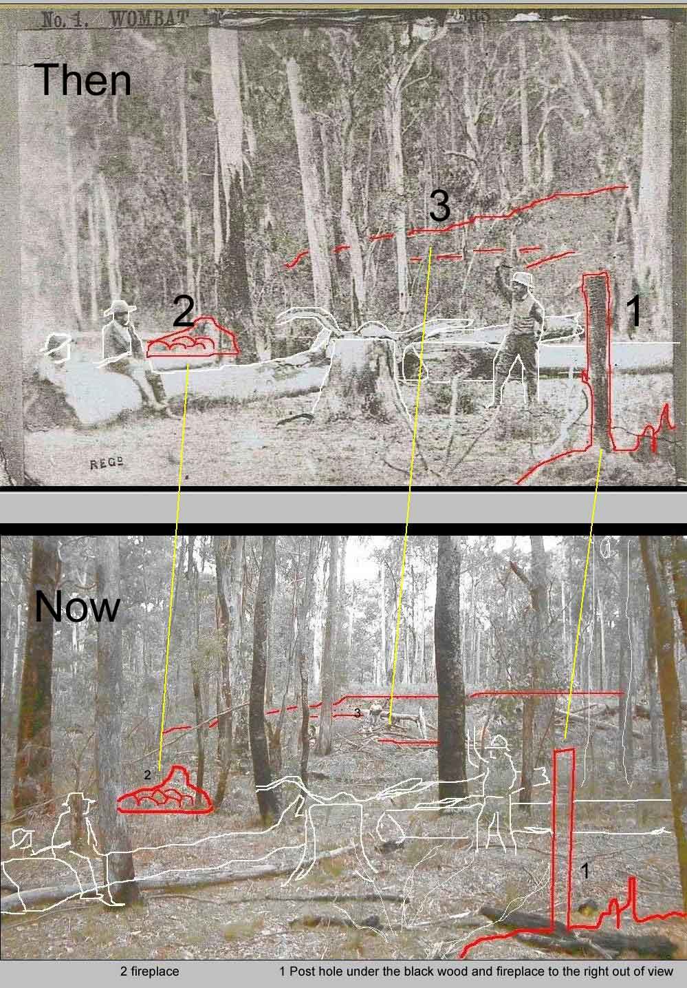
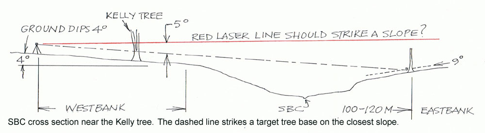
This next posting by Bruce of KC 2000 forum showing two images, one he alleges is the same place but 130 years later, hence he says pictures do lie !
But he has got the wrong location and of course the pictures would be different.


kellycountry2000
Forum Admin


Australia
776 Posts

Posted - 19/06/2010 :  18:37:14  Show Profile  Email Poster  Reply with Quote
Do pictures lie ? yes they do, check this out

http://www.kellycountry2000.com/dopictureslie

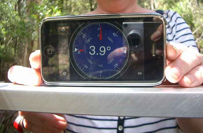
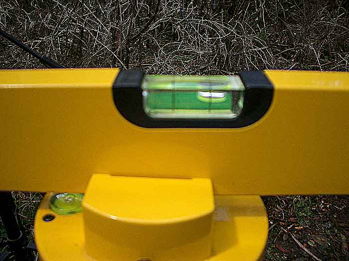
DO PICTURES LIE ?, THE ANSWER IS YES ! ( Please click on the link above )

They can give give false impressions of the angle of the ground and cannot be relied upon in all cases, the first case being the Cuddon picture.
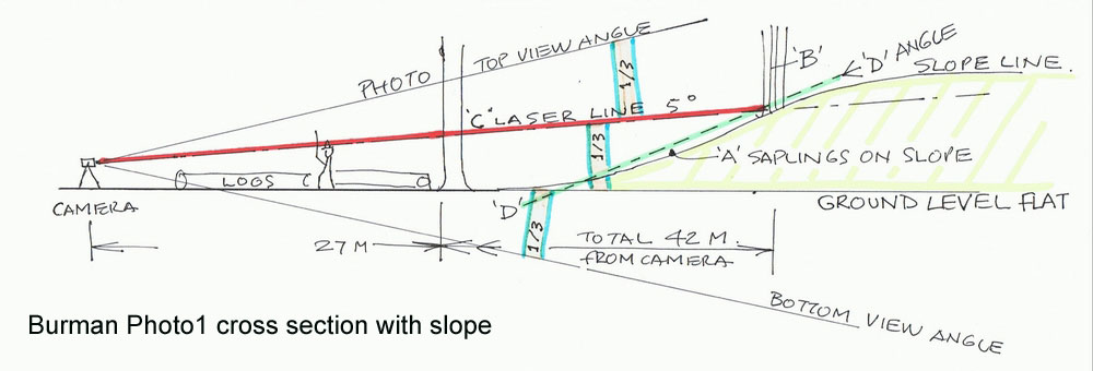
 (url: denheldid.com/twohuts/images/44ktreethirtythree.jpg )

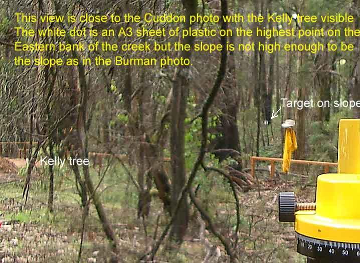
The first picture on the left, which is looking N/E is Mr Cuddon, he is standing on the road at Stringybark Creek, over his shoulder to the left, is supposedly the present day Kelly tree.

For all of you that have been there know that the ground falls away downward to the creek, and the ground at the creek is lower than the road.

The angle of the ground is measured at an angle of 11.8%, but look at the height relationship of Mr Cuddons feet to the base of the Kelly tree, the base of the tree is higher than his feet, giving the FALSE impression that the ground slopes UP, and the tree base is higher than Mr Cuddens feet.

How can this be if the ground falls away and is lower? simple, pictures LIE. The second picture was taken in June 2010, from almost the same location.

Look at the stump in the fore ground on the right of the colour picture,  consider the stump to be Cuddens feet, now look at the height of the base of the Kelly tree in the back ground what do you see ?

You see that the base of the tree looks higher, but we all know the ground actually falls away and the tree base is actually lower, pictures Lie.


bill denheld
Advanced Member


Australia
104 Posts

Posted - 24/06/2010 :  13:53:28  Show Profile  Email Poster  Visit bill denheld's Homepage  Edit Reply  Reply with Quote  Delete Reply
Bruce,

Comparing one scene taken 1930's with another of the same area eighty years later only shows intervening changes.

Photos do not lie because a photo is a record of exactly what was there at that time. ( unless digitally changed by computer)
I understand what you are trying to say, but a picture is not able to tell us too much of ground angles unless the camera has
an inclinometer built into it and angles recorded.

During my investigation at SBC near the Kelly tree during May I took these pictures as a record -


One shows the relative ground angle at 4 degrees dip using a Clinometer (IPhone App ) the other a laser level bubble.
Please notice the smaller bubble is set to level while the laser point level shows a dip down to the left when it was aimed at the
Highest point on the Eastern bank opposite the Kelly tree site.
Your 11.8 degrees may well be right when measured from the road shoulder to the edge of the creek embankment.
But my 4 degrees is only relevant for the portion of ground that a Burman photo would take in if it was taken there ?

This 4 degrees line of sight continues all the way to the Highest point on the East bank that some suggests would have to be
the slope in the Burman photo ! My answer, this gentle slope cannot be the slope because if we examine the Burman photo it is made
up of three parts -
1/3rd foreground sloping at 4 degrees yet it looks flat,
1/3rd slope in the back ground measured at the two huts site as 14 degrees. see section line 'D D'
and 1/3rd upper and sky. ( image below )


Then compare this cross section at the Kelly tree site where there is a creek in between. There is no comparison.


To get the full picture please see my pages 5, 6, 7, 8 to verify the fact no slope exists near the Kelly tree.

Your proposition whether 'pictures lie' by suggesting the base of the Kelly tree is higher up than Mr Cuddon's boots is quite obvious
when a camera held at head height will always be seeing the ground below the lens center line when pointed straight ahead.
But I agree, to the observer flat ground can look as though it is rising when we know it is not. So in a sense you are right, perception
of a scene is not always easy or straight forward, but pictures do not lie.

To get back to the discussion, 'could Burman have taken his photo at or near the Kelly tree' ?
Answer No. Burman photo1 is made up of three parts, 1/3rd foreground, 1/3rd slope and 1/3rd upper and sky.
That is the reason you have to measure the ground angles at the area you consider Burman took his photos.

Can you please show me a photo you have taken near the Kelly tree that even slightly resembles Burman Photo No1
I tried to do that and the result is on page 6 of my document.
http://www.ironicon.com.au/stringybark_ck_the_authentic_location.pdf

Photos do not lie.

Bill
www.ironicon.com.au
 
Go to Top of Page
kellycountry2000
Forum Admin


Australia
695 Posts

Posted - 25/06/2010 :  02:40:51  Show Profile  Email Poster  Reply with Quote
Bill what I wrote was 11.8 PERCENT incline


kellycountry2000
Forum Admin


Australia
706 Posts

Posted - 26/06/2010 :  18:02:54  Show Profile  Email Poster  Reply with Quote
Bill photos do lie I have answered your double post in the other thread.

one pic


Now lets get the contours right, here is a real scale map, with real contours, at 10 mts, if you want smaller contours just draw them in.
At least this is to scale and not a drawing.

If I remember right the 800 mts contour was just above the FP's site but I did not waypoint it, but you can see it crossing the road and going around the valley.

The blue star is a real gps waypoint in the middle of the two FP's +- the epe.

pic 2
Go to Top of Page
kellycountry2000
Forum Admin


Australia
706 Posts

Posted - 26/06/2010 :  19:05:56  Show Profile  Email Poster  Reply with Quote
If we apply the 70 yard distance through the middle of where the two FP's are,
thats from the present day creek to where the tent would have been , which is by the tree stump on the side of the hill, then apply Mc's scale map we get this scale map, of scale logs, which shows the logs over the road, there is something not adding up here.


one pic


Go to Top of Page
kellycountry2000
Forum Admin


Australia
706 Posts

Posted - 26/06/2010 :  19:27:21  Show Profile  Email Poster  Reply with Quote
There are a number of inconsistencies that do not add up when you compare the two burman pictures and these pictures i dont know where to start.

The east west plane, the north south plane, the two fp's are on a mound, where is the elevated ground on the left in the other picture,
there is no sword grass on the side of the hill, to the south is a steep hill not a flat plane like in the other picture, the left of this site falls away to the creek and has no elevated ground, the slope in the burman photo is some distance away here its just the other side of the site

one pic

Go to Top of Page
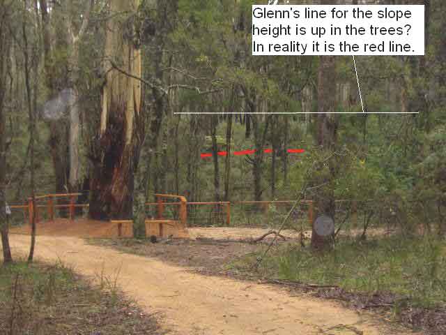
Glenn Standing
Starting Member


Australia
1 Posts

Posted - 29/06/2010 :  15:35:49  Show Profile  Email Poster  Reply with Quote
Hi

I would like to throw this up onto the Forum. The 2 pics show the slope at the Kelly tree and the Burman image showing the post angles?

Cheers,
Glenn

Bill,

Up until this time I have endeavored to be patient & have spent a great deal of time considering your conclusions/findings.
I have watched the evidence comprising of the Burman images and McIntyre#65533;s accounts being ignored, taken out of context or misconstrued so as to suit a particular scenario. When is enough, enough?

The primary sources #65533; the Burman images.
Please refer to the attached Burman No.1 image.

This shows the two burnt posts and their relationship to the log. We can see that the posts are very close to the same angle as the log with the seated figure.
I have noted that you have chosen to twist the angle of the furthest post further away from the log. This I gather is an attempt to make the current fireplace distances and angles fit his scene.

That is to say if we accept that there #65533;May#65533; be some scattered stones of a fireplace around the feet of the standing figure. Quite frankly I cannot see any stones in that area. In any case with the posts at the correct angle the two fireplaces do not fit the scene.

The position of the fireplaces as they are today do not match the Burman images. Fireplace ( Hut No1) faces (10deg North of East) near enough due East and the creek.

The fireplace as you would have it faces more towards the North. That is if you do not decide to move the log angles & positions again.

If we use your scaled plan view of the log layout again the fireplace position do not fit.
If they have been moves since (which would be highly unlikely) they can be discounted.

So it would be fair to say that they cannot be used as any form of evidence.

Regarding the slope at the Kelly tree. Ref. Pages 5,6,7 & 8. In your conclusions.
You have chosen to take a picture looking North down the creek in order to demonstrate the lack of slope behind the Kelly tree. Not East. There is very little slope looking down the creek. In addition you have used the Burman image No.1 on the scope. Yet have endeavored to portray both images. The angles & camera positions throughout your demonstration are not correct. These are misleading.

So again these cannot be used as any form of evidence

Please refer to the attached picture showing a slope behind the Kelly tree.

Regarding your map on page 11 of your conclusions.

The log positions and angles are not as you have them in your scaled layout on page 19. Nor are the hut positions. The camera positions are not correct.
Etc Etc. Again Misleading. It needs to be redrawn.

Cannot be used as a suitable layout.

There are many other questionable conclusions and statements in your findings.

Please reconsider your conclusions.


Regards to all,
Glenn Standing

------ End of Forwarded Message


Picture one


picture 2

Go to Top of Page
PaulOK
Average Member


18 Posts

Posted - 29/06/2010 :  22:01:57  Show Profile  Email Poster  Reply with Quote
Hi Alan and all,

Be Careful... you will labeled a disciple of Mr Jones if you disagree with Bill/Carla theories or even try to mount an educated opinion or "god help you" disagree.

"Well well well what's new, the eternal knockers are at it again".
..for god sake, what sort of childish reply is that? just because someone doesn't agree with you.

Christ Bill, you even had a go at Bruce who runs the forum and accused him of deliberately sabotaging your member account!

Bill/Carla I agree with many posters on the forum that you research is very very detailed and you've put in many many many hours of hard work and you should be commended for it BUT, from an "outsider" It is seems to have become an 8 year hobby/Interest into a blinded obsession to be proven "right" and to be hailed as next "Kelly Messiah" Toxically focused on sticking it up Ian Jones because he "codswalloped you" in a radio interview years ago. Who cares!...get over it

Gee...I'm also confused...quite a while a go I remember the berating I copped from you/Carla? when i had a tongue in cheek jibe, about saying that you were hiding behind your wife's skirt, when i suspected you were using her log in to post...seems I was right!!!..... You were!!!

My GG Uncle (Steve Hart) was accussed of being a cross dresser. Does that make you a cross poster?

You state Ian Jones "belted you" Are you serious?....LMFAO.....Next minute you'll tell us you went 20 rounds out the back of the Imperial Hotel with him.

Paul


bill denheld
Advanced Member


Australia
106 Posts

Posted - 30/06/2010 :  23:58:36  Show Profile  Email Poster  Visit bill denheld's Homepage  Edit Reply  Reply with Quote  Delete Reply
Hello Bruce,
I will start with your comment -
 

quote:


"Now lets get the contours right, here is a real scale map, with real contours, at 10 mts, if you want smaller contours just draw them in.
At least this is to scale and not a drawing".


Your map contours lines are very low res for the area. I know a bloke who worked on mapping. The general contours on these are topographical maps are
merely an indication. He used to sit over stereo photo pairs looking through a stereo scope and on seeing the ground (as photographed from 20.000 feet) and seeing
the ground in 3D, he used a pen to draw in the contours over the photos later to be digitised. You say "at least this is to scale and not a drawing" .
Well Bruce, at least I have gone to the trouble to draw in fairly accurate contours, my map (dated May 2009) is still relevant and I have not changed a thing since.
(See my doc Map page 10. ) Picture contour map -

http://ironicon.com.au/twohuts/images/sbccontourmap.jpg

You then say -
 

quote:


"If we apply the 70 yard distance through the middle of where the two FP's are,


As I have stated before, McIntyre's distances may vary by his own account by 20%, i,e, Mc said the tent from the fire 20 yards and 25 yards, = 20% variation.
So 70 yards could mean 56 yards or 51 metres. ( a yard is .914 of a metre)

In your second map where you placed the two red lines depicting Mc's logs when using 70 yards seems not add up, but let me run this past you and the readers -
The scaled distance from your 700 contour to 800 contour up creek is around around 220 metres.
Pic1, by your scale placement of the two logs, places the police bon FIRE ( where logs meet) at around 44 metres from the creek, then add 20M to the tent makes
it 66 metres, or 72 yards to the tent from the creek.

Now if you accept Mc's measurements were estimates only 70 yards could be minus 20% variation = 58 metres
Secondly, McIntyre's logs (as he has drawn them) are all mighty long, one being 24 yards, where as a 15 M or yards is a big tree log and is more like it.

Given that my sketch layout using Glenn's fireplace measurements (below,) you will see even if the logs as drawn in by me, the bon fire junction point to a tent on the
rise to the west could still work whether on the road or east of it. I certainly would not try to discount this area for the tent as you seem to be doing.
From that tent position you would have a commanding view over the area to the lower level to where the logs lay. Mc said when standing in front of the tent facing east,
to his left a log that lays East west - - - and to his right - (south) there was some 20 yards of clearing and beyond that some spear grasses in the direction of the declivity
( downward slope to the creel and Mc said it was from that direction the four men advanced ( from along the creek.)
http://www.ironicon.com.au/twohuts/images/sbcglennplanandbillslayout.jpg

You then show my composite picture scene looking to south with a portion of Burman photo and below that the Burman photo1, and you ask

quote:


" where is the elevated ground on the left in the other picture,"


you should mean " where is the elevated ground on the right" because the creek is on the left. The elevated ground is on the road side to the right.

You then ask,

quote:


"there is no sword grass on the side of the hill, "


The sword grasses grow along the creek flank. the Kellys came into the camp area from the south along the creek left of the photo (the creek side).
An arborist who takes great interest in botany had a look there and concluded those grass species are very sensitive to drainage changes as with when the road was cut.

You then say-

quote:


" to the south is a steep hill not a flat plane like in the other picture, the left of this site falls away to the creek and has no
elevated ground, the slope in the Burman photo is some distance away here its just the other side of the site"


Not sure what you mean. My scale model reconstruction of the site places the big tree on the right ( Burman1) at around 27 metres and the two tree on the slope at
around 42 metres from the camera. And there is no creek in between the logs and the slope. See my doc page 16

Bruce, you post historical pictures but do not retain original aspect ratios as you have extended Burman photo2 to look like an are of flat ground in a picture.

Hope this answers some of your questions.
Bill


Go to Top of Page
bill denheld
Advanced Member


Australia
106 Posts

Posted - 01/07/2010 :  00:06:33  Show Profile  Email Poster  Visit bill denheld's Homepage  Edit Reply  Reply with Quote  Delete Reply
Hello all,
To those who do not know Glenn Standing, he was part of the team of five one of which including myself in the SBC investigation.
As I could not put my name to their findings, and to date I do not believe they have published their document know CSI at SBC dated March 2010. ( to me as K28 )
It was sent to the relevant authorities at around the time I was advised by them to publish my own.
Hence http://www.ironicon.com.au/stringybark_ck_the_authentic_location.pdf

By the tone of Glenn's posting he appears quite rattled, but I thought the objective of this research collaboration was to find the truth.

Since no forum readers have been able to read K28 - CSI at SBC, it is a proposition that the shootout had occurred near the present day Kelly tree.

The back bone of their case hangs on McIntyre's map with tent and logs placed such that Burman photographed the logs scene looking North East to the Kelly
tree (which by their research, this tree is also to be seen in the Burman photo ?? ) , and despite there being no evidence on the ground of any hut or huts having
been there, nor a descent slope as in Burman photo1, this group relies solely upon McIntyre's written words, and some parish maps dated six and seven years
after the event. It has been demonstrated that apart from Primary source material like Burman's photos the bulk of CSI at SBC document is Secondary source material.
McIntyre did not finish his documentation till close to Kelly's trial and 24 years later his manuscript was completed, so we will never know how much he had forgotten
or how he embellished his accounts of the place, and not forgetting McIntyre was traumatized by the event which could have clouded his memory.


At this point I want all to know that Glenn made me aware of a fireplace he had identified in Burman photo1 - behind the seated figure.
And this made me re look at the Burman photo2 right hand corner to realise the two posts were not the end of the hut, but rather the side wall posts of the hut.
The fact the boots of the standing figure cannot be seen means they are hidden behind material, whether fireplace rocks or dirt over grown with grasses to give
an undefined appearance. With Glenn establishing one fireplace in the photo, this led me to establish the second fireplace which are there for all to see.

Glenn now proposes log angles drawn by me are wrong. He draws attention to log angles in my map sketch, (my document page 11)
but these angles are according to McIntyre's sketch and words. Then he picks out an image on page 16 and claims the angles from two posts are not as I have them
at http://www.ironicon.com.au/twohuts/images/sbcglennplanandbillslayout.jpg and that I have changed things to fit my scenario.
Please see my document page 15 to see the true angles on the model layout - unchanged since this work was first done when Glenn was invited to oversee this modeling.

If Glenn does not want to 'see', then that's up to him, but its up to every reader to make up her / his own mind after examining all the evidence.

As Glenn's group Document has not been made public it remains an unknown quantity for reviewers of this debate.

When will the readers get to see your research Glenn. My document is there for all to read.

Some pictures-


The red line is the maximum slope height level near that site and my targeted white spot in my photo is directly behind your Kelly tree in your photo.
How then can Glenn say my view is looking in the wrong direction 'down the creek' when his own document makes out McIntyre's two logs are those in
the Burman photo and the photo was taken looking down the creek to the North East.

You are now proposing Burman took his photo looking East rather than NE but McIntyre's map shows the logs aligned North S and E West ?
If that was so, then Mc has made a big mistake assuming his two logs drawn were the same logs as in the photo. The only reason Glenn now wants the Burman
photo to be looking East is because he want to take advantage of the meager slope on the other side of the creek. You cannot take a Burman like photo near the Kelly tree.

Glenn, as a matter of interest, can please explain why there is no upright post to support the hand rail right centre. Also a black tree seems to be missing ?
My photo clearly shows a support post? Have you digitally doctored this image to suit your proposition ?

The Kelly tree site your group wants to give credit to does not exhibit one skerric of a hut, huts fireplaces or slope.

Bill
www.ironicon.com.au
 
Stringybark Creek News and Views  
  Go to pages-
Page1,  23,  4,  5,  6,  7,  8,  9,  10,  1112,  13,  14, 
                     Previous Page | Next Page