This is a copy of KC2000 forum  Stringybark Creek News and Views page 3
 

Glenn Standing
Starting Member


Australia
2 Posts

Posted - 01/07/2010 :  15:42:33  Show Profile  Email Poster  Reply with Quote
Bill, I am not rattled at all. Just a little fed up.

Regarding the Two Fireplaces.

Again I draw attention to the fact that the fireplace “Hut 1” as it is today faces almost due East and the creek.

Please refer to your sketch posted on the Forum 7/6.

Notice the position of the two posts in relationship to the log.

Compared to the Burman image in my previous posting.

If we use your scaled plan view (Page 15 of your document) of the log layout.
The fireplace positions, angles & distances do not fit.

Again.

The two fireplaces do not fit the scene. So cannot be used as evidence.


You asked the Forum readers: “Can you please show me a photo you have taken near the Kelly tree that even slightly resembles Burman Photo No1”

I have I believe done just that.
Just a view of a slope behind the Kelly tree.

No proposals. I did not propose that the Burman image was taken due east. Please: Do not make assumptions.

It is clearly obvious that the height of the slope is just fractionally below the white line. The bases of the trees are clearly visible for all to see.

Not where you have indicated with your red line.

The image has not been tampered with in any way. It is as it was taken.

Regards,
Glenn


kellycountry2000
Forum Admin


Australia
708 Posts

Posted - 02/07/2010 :  16:50:59  Show Profile  Email Poster  Reply with Quote
Ok Bill has questioned the validity of the sbc road and creek locations on the forestry map so I have turned off the roads and water coarse feature, and what i have done is this, on a 1:500 scale map I have plotted the following.

The orange stars on the left and line are real gps waypoints, the road runs almost north south.

The orange star on the right is a real waypoint standing in the creek water, and I am sticking with water will flow at the lowest point.

The blue star is a real gps waypoint standing in the middle of the two fire places, the distance between the the two fp's is about 11mts

From the star in the creek I measured out 55mts to the tent, which I think is the fudge factor measurement that Bill wants me to use and then measured another 8 mts from the middle of the tent to the beginning of the east west log, which is the purple star.

Then I measured 12mts which is the east west red line, 12mts is the length of the logs that both Glen and Bill agree on.

Then I scale measured back to where the north south log was.

It does not matter how you want to slew the angle of the logs the intersecting point stays the same and we get the resulting scale map, the distance from the fp's to the creek is about 22mts.
All this still puts the logs up on the side of the side

What else can I do here ?


Author Topic
Page: of 3
Glenn Standing
Starting Member


Australia
2 Posts

Posted - 01/07/2010 :  15:42:33  Show Profile  Email Poster  Reply with Quote
Bill, I am not rattled at all. Just a little fed up.

Regarding the Two Fireplaces.

Again I draw attention to the fact that the fireplace “Hut 1” as it is today faces almost due East and the creek.

Please refer to your sketch posted on the Forum 7/6.

Notice the position of the two posts in relationship to the log.

Compared to the Burman image in my previous posting.

If we use your scaled plan view (Page 15 of your document) of the log layout.
The fireplace positions, angles & distances do not fit.

Again.

The two fireplaces do not fit the scene. So cannot be used as evidence.


You asked the Forum readers: “Can you please show me a photo you have taken near the Kelly tree that even slightly resembles Burman Photo No1”

I have I believe done just that.
Just a view of a slope behind the Kelly tree.

No proposals. I did not propose that the Burman image was taken due east. Please: Do not make assumptions.

It is clearly obvious that the height of the slope is just fractionally below the white line. The bases of the trees are clearly visible for all to see.

Not where you have indicated with your red line.

The image has not been tampered with in any way. It is as it was taken.

Regards,
Glenn
 
Go to Top of Page
kellycountry2000
Forum Admin


Australia
711 Posts

 
Posted - 02/07/2010 :  16:50:59  Show Profile  Email Poster  Reply with Quote
Ok Bill has questioned the validity of the sbc road and creek locations on the forestry map so I have turned off the roads and water coarse feature, and what i have done is this, on a 1:500 scale map I have plotted the following.

The orange stars on the left and line are real gps waypoints, the road runs almost north south.

The orange star on the right is a real waypoint standing in the creek water, and I am sticking with water will flow at the lowest point.

The blue star is a real gps waypoint standing in the middle of the two fire places, the distance between the the two fp's is about 11mts

From the star in the creek I measured out 55mts to the tent, which I think is the fudge factor measurement that Bill wants me to use and then measured another 8 mts from the middle of the tent to the beginning of the east west log, which is the purple star.

Then I measured 12mts which is the east west red line, 12mts is the length of the logs that both Glen and Bill agree on.

Then I scale measured back to where the north south log was.

It does not matter how you want to slew the angle of the logs the intersecting point stays the same and we get the resulting scale map, the distance from the fp's to the creek is about 22mts.
All this still puts the logs up on the side of the hill

What else can I do here ?


Go to Top of Page
bill denheld
Advanced Member


Australia
107 Posts

Posted - 02/07/2010 :  19:35:50  Show Profile  Email Poster  Visit bill denheld's Homepage  Edit Reply  Reply with Quote  Delete Reply
Hello Bruce, I have not had time to suggest much to what you finish with -
" What else you can do here" ? Seems we are stuck in the thinking mud, with ferns and spear grass up to our armpits. We have to separate what is written as 'hard and fast' to what we have by fact.
___________________________________________________________________

Hello Glenn,
I appreciate the debate and respect your input.
You wrote -
 

quote:


Regarding the Two Fireplaces.
Again I draw attention to the fact that the fireplace “Hut 1” as it is today faces almost due East and the creek.
Please refer to your sketch posted on the Forum 7/6.
( http://www.ironicon.com.au/twohuts/images/sbcglennplanandbillslayout.jpg )

Notice the position of the two posts in relationship to the log.
Compared to the Burman image in my previous posting.
If we use your scaled plan view (Page 15 of your document) of the log layout.
The fireplace positions, angles & distances do not fit.


Yes Glenn my sketch plan does show the log angle a little too steep,
Although your two fireplaces drawing was to scale, however I briskly drew in the rest as a schematic diagram to show the position of the logs, creek, road, contours, and slope at that site.

I have compared this sketch plan with your Burman photo grid but find your perspectives in-correct. Sorry but your perspective convergence is wrong.
A good example would be to take a chess board viewed low from one corner, all the lines converge into the distance.
The only way the log would be seen as parallel to the two posts is if the camera was positioned directly between the two posts and this is not the case.
this is of course in correct)

What I should have written was -
' The only way the log would be seen as parallel to the grid is if it was parallel to the grid. And if the camera was moved to photograph that log square on,
the grid lines determined by the two posts would strike the log at angles described below at around 30 to 40 degrees, the same as they do now,
but the camera has taken in both the posts and the log at the same time making the construction of the grid a little more difficult.'


I have redrawn a grid in perspective over your picture to illustrate there is a wedge angle and the log is not parallel to the two posts.


However, not to rely on this small image alone I have also prepared another keeping the correct aspect ratio of the Burman photo as your's was a little stretched -
also giving an impression of parallel lines.


Please notice the long leg of the red triangle facing us starts at the log butt and passes through the stump root structure ( lower right of the stump) proving both Burman photos exhibit the same red triangle on the ground but the distortion in the upper image makes one believe the triangle is in correct.
 
You quote me as saying -
 

quote:


“Can you please show me a photo you have taken near the Kelly tree that even slightly resembles Burman Photo No1” ( I asked Bruce)
You said, Q " I have I believe done just that. Just a view of a slope behind the Kelly tree. "


Glenn, we all know there is a good slope just near the Kelly tree. In my document I point out , while standing there you can look down and see a beaut slope BUT
you cannot take a photo of it if you divide your framed shot with 1/3rd foreground, 1/3rd slope and 1/3rd upper portion, like Burman's camera on a 4 foot high tripod.
Your photo must have room in the foreground for the logs just like in the Burman photos.
Please note this sketch below illustrates what I mean by 1/3rds.


Unlike this cross section below near the Kelly tree which does not illustrate a slope when the camera is set up to take in the foreground


Bill
 

Fitzy
Advanced Member


Australia
144 Posts

Posted - 03/07/2010 :  14:41:44  Show Profile  Email Poster  Reply with Quote
G’day Gang,

Until now I have kept out of the discussion, not having an intimate knowledge of the SBC area of interest and this I must rectify with a trip there, take in all observations and points put forward and see if I can come to any conclusions of my own and who’s theory best fits the scenario.

The whole board seems to be Bill verses the masses and the tone of the topic at times is degenerating to a point not befitting to this website. I believe Bill’s passion is for the truth, not to denigrate anyone else as has been implied, though plenty have fired shots in his direction. It also seems Bill’s passion became more intense when it was announced that the SBC would be redeveloped and why go ahead with this if the actual site was still in question.

To Bill’s credit, it would appear that no one else has put in as much time, effort and detailed research as he has. Bill has also consulted experts (as with the spear grass and contours etc.), to back his findings.

There are a few simple facts that some ought to realise. Firstly, the accuracy on McIntyre’s measurements. I defy anyone to estimate a distance, let alone several distances then run a tape over them and see how close they were. Secondly Mc does mention two huts and the Burnham photos definitely appear to have posts in them that are to high to be part of a fence. So the two huts has to be seriously taken into consideration. There is also contemporary records of these huts in the area, contrary to what Ian Jones has stated. Some have questioned no spear grass on the upward slope! Who would try sneaking up on someone by coming down a slope where you would easily be spotted? Mc’s references say the Gang came out of the spear grass from the direction of the creek, so why these references to spear grass on the slope puzzle me.

I have an open mind on where the actual site is until I can inspect it for myself and put some of the theories put forth to the test. It’s all about the truth, so let’s not denigrate anyone because they have a different view.

Fitzy.
 
Go to Top of Page
Glenn Standing
Starting Member


Australia
4 Posts

Posted - 03/07/2010 :  15:17:38  Show Profile  Email Poster  Reply with Quote
Bill,

Thank you.

I am pleased that we can now agree that there is in fact a good slope near the Kelly tree.

Although the photo I used showing a slope behind the Kelly does demonstrate a reasonably close 1/3 foreground, 1/3 slope, 1/3 upper it was never meant to represent the Burman image 1.

I appreciate you moving the furthest post of the hut to a closer relationship (angle) to the log.


However, I make it quite clear that my sketch of the two fireplaces is not a scaled drawing as you mentioned. Although the distances and angles given are correct it is not to scale as noted in the bottom R/H side.

Regards,
Glenn
 
Go to Top of Page
Joe.D
Advanced Member


Australia
716 Posts

Posted - 03/07/2010 :  16:23:18  Show Profile  Email Poster  Visit Joe.D's Homepage  Reply with Quote
G'day Fitzy,

You wrote.....


quote:


Mc’s references say the Gang came out of the spear grass from the direction of the creek, so why these references to spear grass on the slope puzzle me.


I'm not sure what you are saying here....are you refering to my post/sketch.....?? http://www.ironicon.com.au/twohuts/images/sbcjoesketch.jpg

Joe.D
www.kellyhaunts.org

Go to Top of Page
robert mcgarrigle
Advanced Member


Australia
87 Posts

Posted - 03/07/2010 :  17:05:50  Show Profile  Email Poster  Reply with Quote
Good on you Fitzy, once again you have added a lot of sense to what you have said about this discussion. I say that certain people have a vested interest in rubbishing Bills theories. Everyone and I mean everyone has a right to what they think about the SBC site but please keep the pettiness out. I gave my name to Bills document and have absolutely no regrets as I still think the fireplace site is the correct one but no one will ever be 100 percent sure. Glenn in regard to the slope behind the Kelly tree I have climbed it twice with my family and I am sorry but I don't believe it is the correct slope, however it is more probable than the picnic site and more importantly the current site. To me the thing that stands out most nearly all the researches except Ian Jones (Alan won't be happy me saying that) and the DSE agree that the shootout site was on the west bank of the creek. Lets all work together PLEASE.
Go to Top of Page
kellycountry2000
Forum Admin


Australia
710 Posts

Posted - 03/07/2010 :  17:55:42  Show Profile  Email Poster  Reply with Quote
G'day Fitzy

What may seem to be a veiled reference to a certain geographical locational or feature such as spear grass is fully understood by Bill or Glen as they know the SBC area like the back of their hand , you would be surprised as the the amount of resources that has been expended by many people on this police camp site, I would hate to think what the time and money added up to on this quest and hobby, for some of us it has become nothing to think of the 6 hour drive up and back and only spend 5 minutes there making a measurement and driving home again. 

Fitzy please gather up all the info on the Police camp site you can find, actually go up to SBC and report back your findings as we are all very interested in your conclusion , why should we be the only ones loosing sleep and suffering the stress of this ongoing problem, please join in.
Go to Top of Page
kellycountry2000
Forum Admin


Australia
710 Posts

Posted - 03/07/2010 :  18:41:29  Show Profile  Email Poster  Reply with Quote
Bill with your grids and things do you see the log with the dotted lines how higher than the mans feet do you think the log is and the dotted line in the back ground how far away do you think the back ground is, and no its not a trick question
hmmmm i just observed the sapling/log is about level with the mans head


one pic

Go to Top of Page
Glenn Standing
Starting Member


Australia
4 Posts

Posted - 03/07/2010 :  20:35:26  Show Profile  Email Poster  Reply with Quote
I agree with both Robert & Fitzy. It is important that we work together.
Although Bill & I may disagree to my knowledge we remain on good terms and wish it to stay that way.

It is most important that we keep it straight and above board.


The basis of Bill’s conclusions seems to rely heavily on both the fireplaces & the slope. I have issues with both of these.

I do agree with Bill’s the scaled layout demonstrating the angles of the two main logs.

If we may use this scaled layout and place the (Hut 1) fireplace in the location and angle as Bill is suggesting the layout does not make sense.

The direction the (Hut 1) fireplace faces 10deg North of East almost due East and the creek. This being the case the log angles also change. We no longer have almost due North /South log.

In addition the location of the second fireplace would not fit the Burman images.

I cannot yet see how the fireplaces fit the Burman images.


Regards,
Glenn


bill denheld
Advanced Member


Australia
108 Posts

Posted - 06/07/2010 :  16:00:57  Show Profile  Email Poster  Visit bill denheld's Homepage  Edit Reply  Reply with Quote  Delete Reply
I thank all for their postings. And a special thanks to those who are supporting me.

I will go down the list starting with reply to Bruce's posting near the top of this thread page.

Bruce, on 02/07/2010 you wrote, - ( how you find it all confusing)
( Blue, orange and crimson stars, some red lines etc)

You finish with " What else can I do here ? " Bruce, may I ask why you have a star at the end of the log ?
I understand you want to plot the 70 yards from the creek when I have suggested it may only have been 56 yards.
May I suggest you diminish McIntyre's seemingly un questionable measurements to estimates. Also forget those two right angled logs he drew like an up side down L.
Do not accept McIntyre as gospel. Mc did an amazing job recalling and recording so much detail with variations.

If readers of this debate want to be fair they should be able to see the alternative document sent out by the other four, and on this forum I have asked Glenn this question without response.

Then on 03/072010 Bruce you make a posting KC2000 to Fitzy-

quote:


" G'day Fitzy

What may seem to be a veiled reference to a certain geographical locational or feature such as spear grass is fully understood by Bill or Glen as they know the SBC
area like the back of their hand , you would be surprised as the the amount of resources that has been expended by many people on this police camp site,
I would hate to think what the time and money added up to on this quest and hobby, for some of us it has become nothing to think of the 6 hour drive up and back
and only spend 5 minutes there making a measurement and driving home again.

Fitzy please gather up all the info on the Police camp site you can find, actually go up to SBC and report back your findings as we are all very interested in your
conclusion, why should we be the only ones loosing sleep and suffering the stress of this ongoing problem, please join in.


But then sometime later you add these Para's-
 

quote:


" From his own website "Now read Bill's conclusion for identifying the authentic site." and "Please click on the image to see Bill's definitive document to
establish the authentic location." and "If anyone has anything they wish to add to this article or if they wish to correct or confirm anything, please feel
free to contact this site, as we are all on a journey to find the truth! "

Mcintyre is a conundrum , At the recent talk by the FBI trained police expert he stated that Mc could be believed up to a point then he falls apart,
Mc gives very specific details which have caused us all a great angst when we have tried to apply his info to the very ground at SBC.


Bruce, are you making these statements on behalf of someone I recognize ? as the words don't seem to be your style ?
However this raises the point that attention is being focused on my document while the opponent's document has not even been tabled.
By all means pick my document to bits but at the end of the day either accept or reject and tell the forum why its wrong.

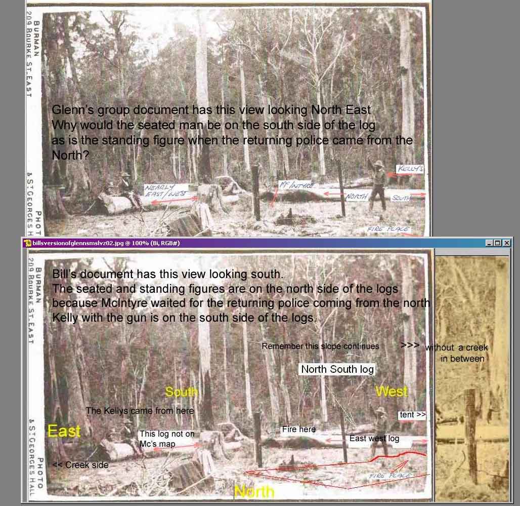
To understand my document you will need to -
First, accept my reconstruction log model of Burman photos as correct, (see my PDF document pages 14 and 15), you will see the logs are more like a back to front y.
Second, if you want to stick religiously to McIntyre's map orientation with his L shaped logs, please see he was all mixed up, see pages 17,18,19
Third, forget Mc's measurements from the creek to and fro. Would Mc have have had a tape measure with him? they are only estimates that sound official.
Forth, the Burman photos are looking South. And that Mc thinks his logs are those in the Burman photo facing the viewer looking south.
Fifth, accept the value of a Viewer Scope to identify a site by looking through the outline of the Burman image.
Sixth, that the 1884/5 parish maps showing locations are basically wrong, one map shows the hut at 804m mark, the other at 645 m mark.
Seventh, that Glenn's identification of a fireplace in the Burman photo pulls the Burman photos to the Two huts site at SBC.

If you can not agree to all these above 7 points, then my research documents at www.ironicon.com.au cannot be understood..

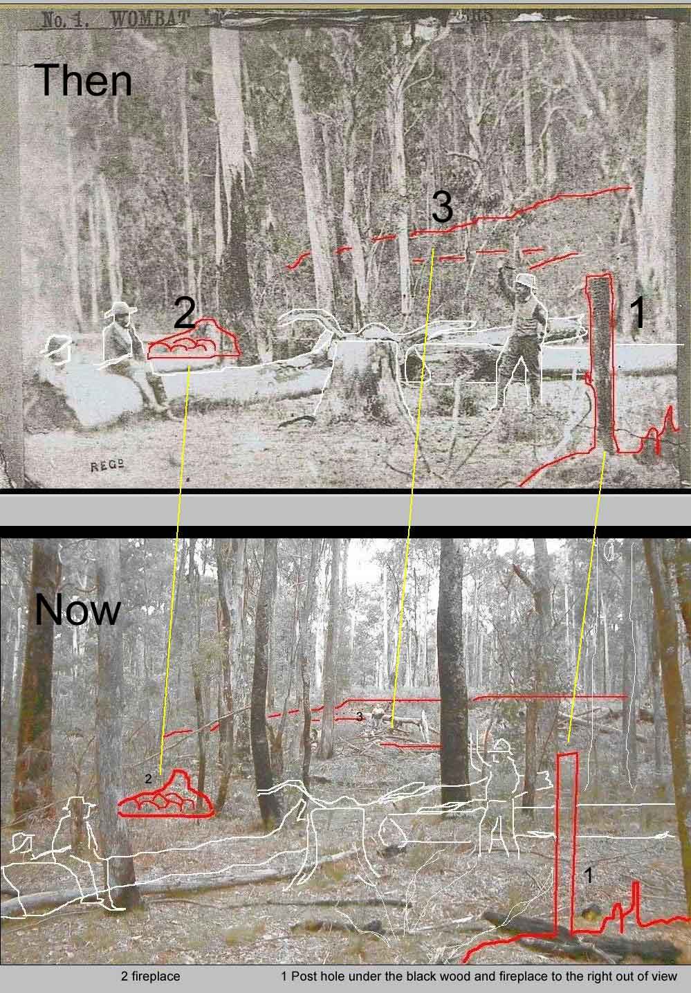
Then 03/07/2010 KC2000- Bruce writes
 

quote:


" Bill with your grids and things do you see the log with the dotted lines how higher than the mans feet do you think the log is and the dotted line in the
back ground how far away do you think the back ground is, and no its not a trick question
hmmmm i just observed the sapling/log is about level with the mans head


By my calculations the saplings are laying not more than 10 metres behind the seated figure. See map below. It would apear the ground gently rises, but I think it is
more likely to be fairly level ground and because the camera is higher than the ground it will give the impression the ground rises when it is not.
But how far is the background ?? say 35 to 40 metres.

--------------------------------------------------------------------------------------------------

Then on the same day
Glenn wrote 03/072010

quote:


" The basis of Bill’s conclusions seems to rely heavily on both the fireplaces & the slope. I have issues with both of these.


No Glenn, my document was out in Feb 2010, and only relied upon the slope as hard evidence and with the two huts as Primary source material.
It was not until mid May that you told me about the fireplace identified in Burman1 photo.
Since then I identified the strong possibility the second fireplace was also in view, Burman2 photo.

After you challenged me about the log angle to the two posts, you wrote -

quote:


" I do agree with Bill’s the scaled layout demonstrating the angles of the two main logs.

If we may use this scaled layout and place the (Hut 1) fireplace in the location and angle as Bill is suggesting the layout does not make sense.
The direction the (Hut 1) fireplace faces 10deg North of East almost due East and the creek. This being the case the log angles also change.
We no longer have almost due North /South log. In addition the location of the second fireplace would not fit the Burman images.
I cannot yet see how the fireplaces fit the Burman images."


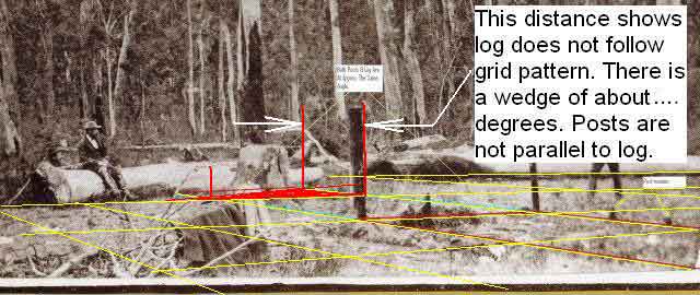
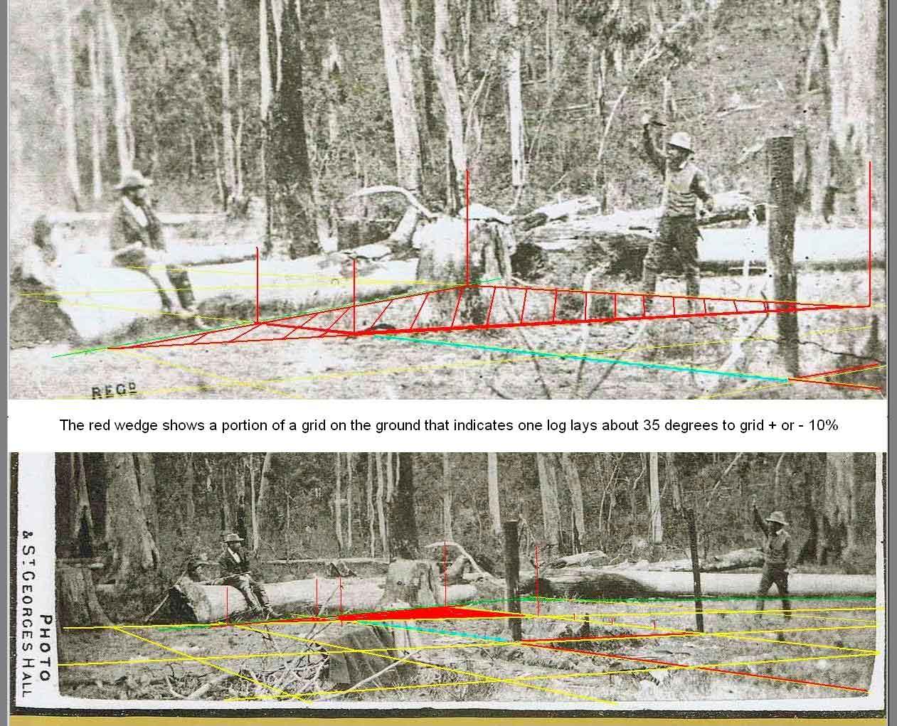
Glenn, if as Mc said one log was East West, the other nearly N,S, and as we have now established the two posts are about 35 degrees to the log, we have had to turn
the whole Burman scene clockwise to line things up with the fireplaces orientation. With this done, we now see the east west log is turned to West NW and East SE
This does not mean anything has changed in reality, who said everything had to be on a perfect grid. McIntyre thought his left log lay east west when it was not actually so.

Glenn, you have identified one of the fireplaces in the Burman photo, this to me was a break through. You should accept this as a mile stone towards identifying the correct site, yet you
dither about relatively petty issues because you want the site to be somewhere else.

Later I identified the second fireplace in Burman2 photo, and now if you look at my scale layout picture below, it all fits.-
I do remember you telling me you believed my photo reconstruction models were close to reality. If you accept Burman's photo logs do not form an L but rather a Y,
why then can't you dis regard Mc's L configuration. I have demonstrated " L " right angled logs never existed . McIntyre used the Burman photos to construct his map, ( for Ned's trial)
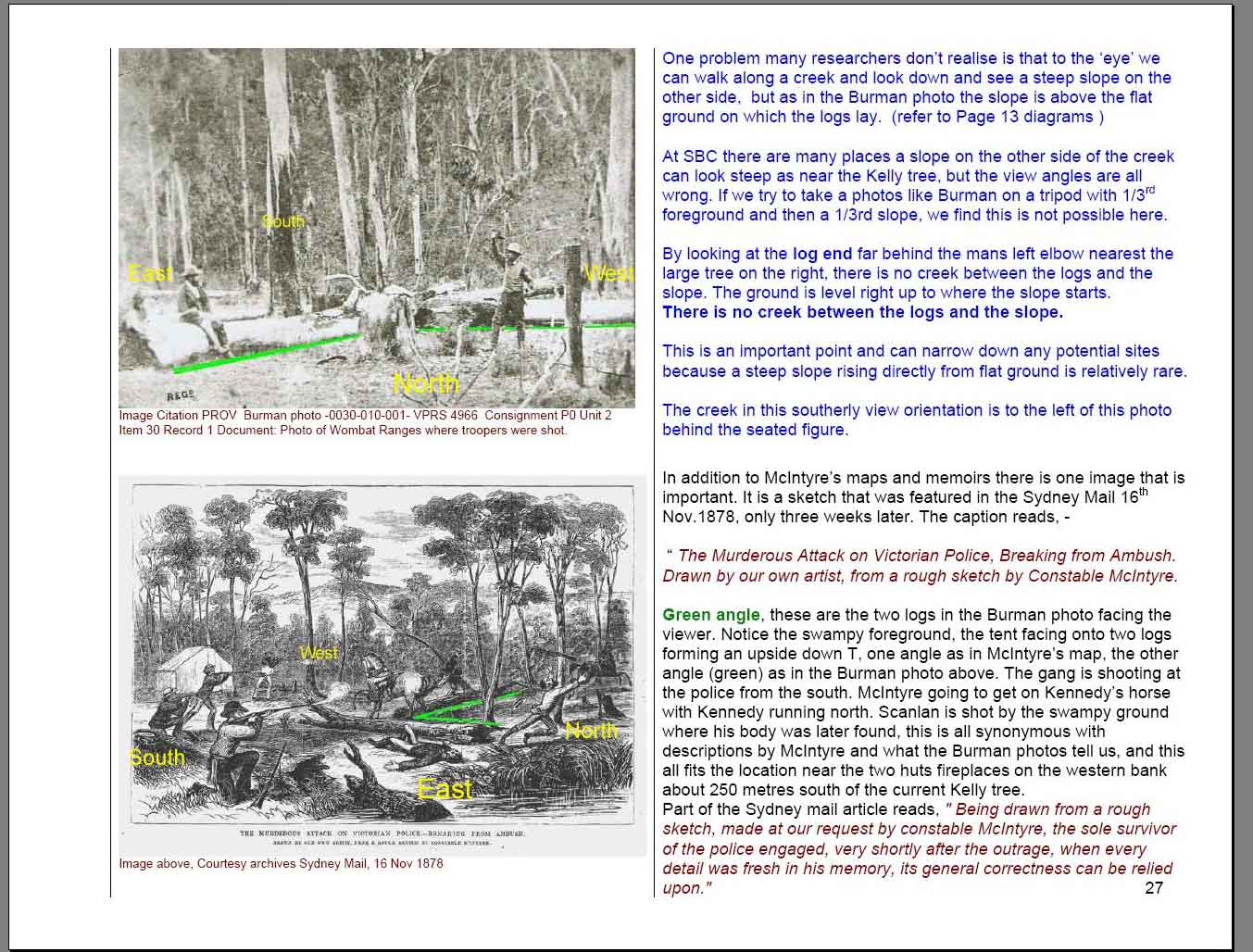
McIntyre within days of the shootings gave his information to an artist with the Sydney Mail who created what could be the closest pictorial image of the scene -see my Document page 27.
I know your group has tried to poo poo pictorial illustrations of the SBC event but this one closely matches the two huts site and should not be ignored.
The text read it was drawn with Mc's endorsement. Notice where the tent is in relation to the logs and the swamp. This swamp cuts across north of the two huts site quite close to the road.

And while we are at page 27, note your other posting,
Glenn wrote - 03/07/2010,
 

quote:


Bill, Thank you. I am pleased that we can now agree that there is in fact a good slope near the Kelly tree.


Glenn, my second para on page 27 reads,

quote:


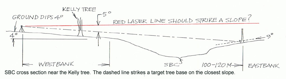
" At SBC there are many places a slope on the other side of the creek can look steep as near the Kelly tree, but the view angles are all wrong.


Here then is the latest scale layout. Burman2 photo are greenlines and Burman1 photo in purple


And the Then and Now


And -


kellycountry2000
Forum Admin


Australia
713 Posts

Posted - 06/07/2010 :  18:53:22  Show Profile  Email Poster  Reply with Quote
Bill on the first page you asked me this


quote:


What makes you think my measurements or positions do not add up ? What measurements or positions?

Please explain,Bill


There is your invitation, So thats what i have been doing in plain english,

the purple star is the beginning of the east west log
thanks for your estimates of what I asked about


quote:


I understand you want to plot the 70 yards from the creek when I have suggested it may only have been 56 yards.


I made another map with 56 yards, and that still shows the cross point of the logs above where you say they where, now you want me to move the creek twenty mts, I made another map (not shown here) and the cross point is still above where you say they where


quote:


Bruce, are you making these statements on behalf of someone I recognize ? as the words don't seem to be your style ?


NOW what are you accusing me of, lieing ? with my answers, My response to Mick was to him, Mick and I are school mates from 1968, you invited me/us to scrutinize your work, and i was politely replying to Mick, telling him what was going on.
more later after i apply more stars to some maps

Go to Top of Page
Glenn Standing
New Member


Australia
5 Posts

Posted - 06/07/2010 :  20:06:29  Show Profile  Email Poster  Reply with Quote
Standing at the tent entrance and facing the creek there was upon the left front a felled tree nearly 4ft in diameter, at the thickest part.It lay nearly east and west. About midway this log was joined by another which lay due north and south and terminated where it joined the other. These two logs thus formed two right angles, the point of junction being about 25 yards from the tent.

Thomas McIntyre
This picture is labeled
Go to Top of Page
poorflour
Average Member


12 Posts

Posted - 08/07/2010 :  13:35:46  Show Profile  Reply with Quote
Wasn't Mr Thomas McIntyre the only witness who was present at the Police camp ?

If so then what he mostly writes about the location of the camp and where the tent and logs where should be beleived.

If his verbal description is not the same as Mr Burmans photograph then one has to question the photograph, was it fabricated for the court.

There is a big diffenrence in a person judging something that is 100 meters away and then only calling it 20 meters, what would Mr Thomas McIntyre have to gain with not making his discription accurate ?

The Wang school girls rule

Edited by - poorflour on 08/07/2010 13:41:38

Go to Top of Page
bill denheld
Advanced Member


Australia
109 Posts

Posted - 09/07/2010 :  13:43:21  Show Profile  Email Poster  Visit bill denheld's Homepage  Edit Reply  Reply with Quote  Delete Reply
Hello Poorflour,
Poorflour reminds me of poor McIntyre who had to endure humiliation for escaping his ordeal at Stringybark Creek.
Not only did he escape, he had to make a full report as a police officer in order to ensure a conviction of Ned Kelly.
He only returned back to the scene once to identify the site and get the bodies of his colleagues out, a journey started in the middle of the night and he would
not have hung around too long.

In the above, Glenn's posting, quotes Mc's description looking from the tent regarding the distance to the fire is from Mc's Manuscript dated at around 1902, -
hardly primary source material ? The only other reference to the fire and tent distances is from The Age 6 August 1879 as reporting Kelly's preliminary trial at
Beechworth, again hardly riveting Primary source material being 10 months after the event. In fact any historian would classify this information as Secondary
source material from a first person witness.

Poorflour you wrote -


quote:


"Wasn't Mr Thomas McIntyre the only witness who was present at the Police camp ?
If so then what he mostly writes about the location of the camp and where the tent and logs where should be believed.
If his verbal description is not the same as Mr Burman's photograph then one has to question the photograph, was it fabricated for the court.
There is a big difference in a person judging something that is 100 meters away and then only calling it 20 meters, what would Mr Thomas McIntyre
have to gain with not making his description accurate ? The Wang school girls rule"


I make the following points -

McIntyre was not the only witness. The Kelly gang survived the shootings as well.
McIntyre did not tell us where along Stringybark Creek his big event took place, but the Kellys did, at the Shingle Hut
At Ned Kelly's trial the Burman photo was Exhibit A, and McIntyre verified to the magistrate the photo was of the place of the attack.
The photographers guide was Mr Monk who was present when McIntyre showed him the place so we can be sure Burman photographed the proper site.

Nobody is claiming 100 Metres could be 20 metres. What is being discussed is one of McIntyre's reports states from the tent to the fire as 20 yards and in another 25.
In percentage terms this is 20% percent different. It could be extrapolated therefore that 70 yards could could have been 56 yards or 84 yards.

Therefore it would be wrong to suggest 70 yards is hard and fast, unless we have proof he had a tape measure with him. Likewise with his compass bearings,
he probably knew the creek ran North South but as the creek meandered around a fair bit he probably remembered only the area around the raised ground
near the two huts where they pitched the tent.

It is interesting to note that there is swampy ground immediately north of the two huts site with the creek to the east, and that Constable Scanlan's body was
found some short distance down stream from the logs, (shoot out position) and Mc did have a good idea of the logs orientation as he sat one facing north when
the other officers arrived back to camp because he noted "the sun sank to his left" West.

McIntyre knew which way the logs lay, but there was also the Burman photo which he had to reconcile with and without doubt used it to construct his map erroneously
because the Burman photo shows 3 logs and his map only 2. It is quite clear Monk and Burman photographed the correct place according to what McIntyre had shown them,
but the figure placement was left up to Monk and Burman and here they made mistakes by placing the seated figure on the wrong left hand log in the photo,
when Mc should have sat on the right log with Kelly on his right, and Kennedy (standing) on his left. The photos are looking south.

Please read my opening pages 3 and 4 and orientations 14 to 19 to understand this.

Bill

PS, link to http://www.ironicon.com.au/stringybarkckinvestigation.htm
and do a Search, click Edit, - Find on this page, the words " 20 yards " click next till you find them all
Now do the same with 25 yards and you will see the investigation team refers to 25 yards only from McIntyre's Manuscript but nowhere in the
official court reporting in newspaper or other reports does it mention 25 yards.
McIntyre's descriptive narratives are nothing more than painting the scene using words.

 
poorflour
Average Member


13 Posts

Posted - 09/07/2010 :  15:31:58  Show Profile  Reply with Quote
Bill, We call ourselves Poor flour because that horrible man with the big head from his self-inflated opinions of himself, and has no respect for anybody, called us Poorflour.

When we saw your newspaper article from Mansfield, our science teacher took as all to Stringybark Creek, our teacher is a very smart lady, we had a nice picnic , and found some little plants.
 
Go to Top of Page
kenny t
Average Member


Australia
11 Posts

Posted - 09/07/2010 :  18:58:39  Show Profile  Email Poster  Reply with Quote
Bill
I am reading this debate with interest and it is good that other people have also done a lot of research.
I wonder if you could put on your latest scale map where the "spear grass" was growing.
I believe this is the area from where Kelly approached the camp from. Also if you have it a distance as well.
thanks
Go to Top of Page
Thomas McIntyre
Starting Member


1 Posts

Posted - 11/07/2010 :  01:17:34  Show Profile  Email Poster  Reply with Quote
Oh well I think the time is nigh for me to say a few things about that terible experience I went through back when the boys ambushed me and my collegues at Stringybark Creek.
It seems that what I wrote or said so long ago - including my extensive story which took a number of drafts and which was done over many years - and which you can all now read thanks to the people who have put it on the net, is being subjected to much scrutiny and subjective analysis.
Don't forget that I was on the ground at that place for about 27 hours !
I spent that time attending to our horses, camp duties and in walking about the place including fetching water from the nearby creek for the horses and for us.
Oh, and I have a reasonably good recollection of what happened there and how far it was to the creek and our tent from the main fire we made and apart from my own observations I also used my compass to work out the cardinal points.
Once I get used to all this new technology I will be making some more comments and posing questions to those who are trying to unravel the true story of the time and place.
Go to Top of Page
alanros
Advanced Member


Australia
66 Posts

Posted - 11/07/2010 :  13:12:02  Show Profile  Email Poster  Reply with Quote
Welcome Tom,for a bloke who's 164 years of age you have not only a remarkable constitution, but a remarkable memory. It's a shame your memory wasn't as sharp in delivering your evidence at Ned Kelly's Prelim. Hearing at Beechworth, and at his trial in Melbourne. I suppose you are also lucky to still be alive. Your brave Sergeant could well have decided to hold onto his horse and make his escape, leaving you alone to deal with those dastardly Kellys. But as they say Thomas....Such Is Life!!
Go to Top of Page
bill denheld
Advanced Member


Australia
110 Posts

Posted - 11/07/2010 :  19:30:50  Show Profile  Email Poster  Visit bill denheld's Homepage  Edit Reply  Reply with Quote  Delete Reply
Hello Poorflour,
I appreciate your colorful description of the big head who named you so poorly. I am pleased you had a great day at SBC. You say you have a very smart teacher,
I don't doubt that for one moment. The important thing is you are getting involved with history, and who knows where that will take you in the future.
However, having said that, there is current talk of downgrading Australian History ' Revolutions' section of the state's most popular year12 history course.
What a dumb idea that would be ? By the way, while at SBC, did you get to see the two fireplaces at the two huts site across the creek from the current but incorrect Police camp site ?

____________________________________________________________________
____________________________________________________________________

Hello Kenny T,
I have re uploaded my scale map with references to 'Spear Grasses' that still grow at the two huts site.
Regarding measurements, because the map is scalable you can work out any distances using the 'scale' as per the yellow grid which is 3 metres or 10 feet square in old imperial.
The vertical three striped tufts indicate where spear grasses and ferns may to grow.

To see a picture of the spear grasses at the two huts site go to Sheila Hutchinson and Fay Johnston's webpage http://www.ironicon.com.au/validlinks.htm you will read that of recent times,
(2004), Sheila and Fay proposed the site was on the Western bank of Stringybark Creek. Interestingly, Sheila lived just near Stringybark Creek, and by mutual interest to produce this
document, Fay's husband is a descendant of the Burman family of photographers, " who traveled to Stringybark Creek and took a series of photographs of the scene of the tragedy
in November 1878." These two ladies have provided a great deal of important SBC history.

______________________________________________________________________
______________________________________________________________________

Hello Glenn,
Regarding your above posting 06/07/2010, you added an image of the Burman photo with your notes on it.

The figures in your 'labeled' Burman photo would be facing south, that is if you believe the photo is looking North East.
McIntyre clearly stated 'they' faced North while waiting for the returning police Kennedy and Scanlan.
As well the (standing) figure representing Sgnt Kennedy on his return from north approaches McIntyre in the direction of the right log which lay East West.
(Mc said facing north and the sun sank to his left.)
We know this because Ned fired a shot at Kennedy that missed because Mc was between the two and the three formed a straight line along the direction of that log.
Kennedy came in from higher ground Quote from transcript text record at http://www.ironicon.com.au/stringybarkckinvestigation.htm provided by Kelvyn Gill, -
" I was in a direct line between him and Kennedy, who was on higher ground, Kelly had to shoot over my head and in doing so fired too high to hit him"


Glenn, in your scenario with Mc facing south Kelly would be shooting at Kennedy in a South easterly direction .

The log in your image you label 'nearly East West ' is the log that is missing in Mc's map.

The issue is this -

According to McIntyre's map he has marked himself on a log facing south by mistake, seemingly because he has used the Burman photo as his reference to create his map.
See my document http://www.ironicon.com.au/stringybark_ck_the_authentic_location.pdf pages 17, 18, 19

Also, when Burman and Monk set up the photo, they had Mc facing North BUT on the wrong log, -

We know this because Ned Kelly (with the gun) was kneeling by the fire ( logs centre) and almost got himself burnt.

Waiting for the returning police Ned had told Mc to sit on that log to his left (10 yards off), Kelly was on the creek side. In the Burman photo Mc sits besides Ned but to his left on the wrong log.

Bill

Please take a look at the images below.


Picture http://ironicon.com.au/twohuts/images/twoviews.jpg


Picture http://ironicon.com.au/twohuts/images/sbctheauthenticlocationpage27.jpg

______________________________________________________________________
______________________________________________________________________

Dear Mr McIntyre,
How timely for you to get involved and help sort out a few of your indecorums. ( today we call them a blunder or a stuff up )

Mind you, most would not realise the mistakes, but had that lawyer of Mr Kelly noticed the bungled map and photo orientation, the prosecution case for murder may have failed.
I say this because had Mr Kelly been able to show inconsistencies in the case against him, he may have had more time to mount a defence.
You must have known there was something wrong and hoped nobody would notice that you were on the wrong side that log on your map, and that your map did not tie in with Mr Burman's photos!

Was that when the magistrate said " Doubts as to the accuracy of the scene (leading to reconstructions) perhaps been stimulated by a sense that this is a fairly unusual piece of evidence to Introduce”.
What exactly did he mean by that dear fellow ?

I suppose it was all to do with having a neat black and white case to throw at Mr Kelly, and put it all behind you. What do you say to that Mr McIntyre.

PS, Mr Mc, have you conferred with Captain Jack Hoyle (equally retired) who I believe is also very knowledgeable on these matters?


Thomas McIntyre
Average Member


14 Posts

Posted - 11/07/2010 :  23:50:35  Show Profile  Email Poster  Reply with Quote
Hello, and thank you Mr Alanros.
Your comments are interesting and I appreciate your thoughts but of course Ican't agree.
I swore depositions, was twice in the witness box and subject to cross examination and of course the newspapers reported extensively in their words what they heard or remembered from their notes from both the committal hearing at Beechworth and the criminal trial in Melbourne.
I think any fair reading of my depositions and evidence will show a
consistency of statements.
And of course over a period of many years I worked to prepare my memoirs,again which are consistent with my earlier statements.

I do intend soon to place on the record yet again my words which were recorded in my depositions so those with an interest in establishing the whereabouts of our camp at Stringy Bark Creek can consider the only eye-witness !! descriptions of it.

PS In my depositions I mention the remains of A HUT not two ! as some now use to try and establish where the camp was.
Oh, and IF no-one had survived that time at the Wombat then what case would the Crown have had to pursue the conviction of Ned ?? I think NONE.
"Oh well, I suppose it has come to this"
 
Go to Top of Page
alanros
Advanced Member


Australia
67 Posts

Posted - 12/07/2010 :  13:37:46  Show Profile  Email Poster  Reply with Quote
My dear McIntyre, I must thank you for your prompt and courteous reply to my last posting.
I am waiting most patiently for you to bring an end to this seemingly eternal debate on the true whereabouts of your campsite at Stringybark Creek. As I am no expert in such matters, I must digress for a moment to ask just one question of you. In your evidence sworn to the courts in both Beechworth and Melbourne regarding the actions of your colleague Thomas Lonigan directly before his death, and in all good conscience…. did you tell the truth, the whole truth, and nothing but the truth, so help you God? If your answer is yes, then your valuable input into the campsite’s whereabouts will be long awaited. But if in all good conscience your answer is no, then how are we to believe in all you have to say? I must also remind you, that if you swore false witness in a court of law, bringing about the death of one Edward Kelly, you have much to answer for. Could this possibly be the reason, at the age of 164 years, you have refused to meet your maker,or maybe you are simply afraid that someone has been patiently waiting to see you there, where he goes?
 
Go to Top of Page
bill denheld
Advanced Member


Australia
113 Posts

Posted - 13/07/2010 :  13:13:02  Show Profile  Email Poster  Visit bill denheld's Homepage  Edit Reply  Reply with Quote  Delete Reply
Mr McIntyre,
I am bitterly disappointed you have not answered my question and I am loosing faith in your integrity.

You said

quote:


" Once I get used to all this new technology I will be making some more comments and posing questions to those who are trying to
unravel the true story of the time and place."


My question to you was, ' by the court evidence suggesting your map of the place does not fit Mr Burman's photos'. My dear fellow, are you avoiding the question ?
However you answer Mr Ros . but refer to the issue at hand as a post script PS,
-

quote:


" In my depositions I mention the remains of A HUT not two ! as some now use to try and establish where the camp was.


Mr McIntyre you refer to me as ' SOME ' , rather impertinent don't you think ?

Mr McIntyre your memory is defunct , but WE know what you reported to your superiors and to the press just after your scramble back to town so long ago.

quote:


[BY ELECTRIC TELEGRAPH ] FROM OUR SPECIAL REPORTER MANSFIELD, MONDAY NIGHT
From the account given by Constable M'Intyre, it appears that the Mansfield party started on Friday, equipped with revolvers, one Spencer rifle, and a double barrelled gun,
lent by a resident of the township. They had a tent and a fortnights provisions. They reached Stringy-bark Creek, 20 miles from here, on Friday evening, and camped on an open
space on the Creek. It was the site of some old diggings.
They pitched the tent near the ruins of two huts.


Mr McIntyre, That should refresh your memory.

Source, The Argus 29th October 1878
http://trove.nla.gov.au/ndp/del/article/5918902


Go to Top of Page
Fitzy
Advanced Member


Australia
146 Posts

Posted - 13/07/2010 :  22:37:01  Show Profile  Email Poster  Reply with Quote
G'day Tom Mc,

You raise some very interesting points and give a new perspective on the events at SBC and they should be taken into account! Though, as Alan has pointed out, your memory appears to be better now than it was at the time. Perhaps you should have taken your own eye witness account into perspective when giving different versions of the event and layout, in depostitions and consequent trials, as pointed out by Alan and Bill. Like Alan, I would like to see you go a few rounds with Capt Jack (retired), but be ware, you could end up walking the plank, so I hope you can hold your breath for another 164 years.

By no means let the/us detractors deter you, as you do add a diferent perspective to the debate. We may just have to hold a seance at the SBC and summond you, to alleviate everyone's curiosity as to the actual site of the police camp (as Bill has asked for), whilst on their mission, trying to carry out their murderous intentions towards Ned and Dan Kelly.

Fitzy
Stringybark Creek News and Views  
Go to -
Page1,  23,  4,  5,  6,  7,  8,  9,  10,  1112,  13,  14,  15,  16,  17, 18,  19,  20
                               Previous Page | Next Page