Glenn Standing
Senior Member

Australia
31
Posts |
 Posted - 08/09/2010 :
18:45:49 Posted - 08/09/2010 :
18:45:49 


|
Don't let them rattle you Maxi.
The Kelly tree location with the Burman photo view looking N.East is
not broken at all. It remains the most logical location.
It is to be remembered that the Kelly tree is some 23yrds from the
creek. With a good slope behind to the right. The slope is visible in
both Burman images.
As far as "Toscas" go I could name a few but you certainly are not
one. |
 |
|
Glenn Standing
Senior Member
Australia
31
Posts |
Posted - 08/09/2010 :
18:58:56
|
By the way Bill,
your Hut2 fireplace position is still not correct. As I have proven
previously. |
|
|
|
Thomas McIntyre
Senior Member
33
Posts |
Posted - 09/09/2010 :
18:48:58
|
Well, after attending to matters
both judicial and private I now return to the task of critical and
analytical analysis of the supposition argued by Mr Denheld in regard
to the position of our camp site at the Wombat.
But first to Mr. Max.
I see Mr Standing has offered his opinion and it is certainly one I
endorse.
Don’t be put off Mr Max you are yet another in what I believe to be an
ever increasing squad not sharing the analysis of Mr Denheld’s.
I would just offer this for present. If you have indeed read my first
draft of my story (the one now retained within the walls of the
Victoria State library) at page 15 you will have got the North east
reference which was used therein.
I spotted this error of transcription and it was immediately corrected
to read the North West corner as I continued over much time to make
newer updated manuscripts - a slow laborious job with only a
typewriter and pencil at my disposal over many years to get the work
to a final, and hopefully a publishable state (alas this did not
eventuate although I did try).
Now for matters in general
I wonder why an axe is shown in the sketch to which Mr Denheld draws
our attention?
I would suggest it is just an artist’s jape as he did not attend at
the scene ever and by inclusion of the axe is signifying this to the
observant reader.
Or perhaps we should all now spend the next millennium attempting to
find it in the photographs of Mr Burman?
Whilst I continue to assemble more material of relevance to this
matter I will not be too active within this topic, but I will be in
due time.
Your humble correspondent
Thomas
|
|
|
|
Fitzy
Advanced Member
Australia
161
Posts |
Posted - 10/09/2010 : 10:36:12
|
G’day Max,
Thanks for posting your version, as that now gives us something to
study and digest.
“Gone for a Tosca” was a common saying back in the early 70’s when the
commercial for that wafer and chocolate bar was sold and it was not a
derogatory term. There was a sting of commercials and ‘George’ was
always going missing and when someone would ask, “Where’s George?”,
the reply was always, “He’s gone for a Tosca”, as he was addicted to
them.
Fitzy.
|
|
|
|
robert mcgarrigle
Advanced Member
Australia
116
Posts |
Posted - 11/09/2010 :
11:45:18
|
Max in regards to your markings
on the Burman photo on your posting on the 5/9/2010 I would like you
to confirm some of these questions. First of all you show the Kellys to
the right hand side of the photo BEHIND the standing man. You show
south also behind the standing figure, would that be correct? If this
is so I agree with you. I know this completely contradicts both Bill
and Glenn as they say the standing figure is to the North. Glenn points
out on the markings on the Burman photo on the 1/8/2010 that the slope
is to the west and he shows where roughly the current road exists. You
show on your markings with the blue star that you say it is to the
east and I have to admit that I agree with you again. Also thanks Max
for providing your markings and opinion of the orientation of photo.
Also the imposter McIntyre states that he agrees with Glenn, although
he hasn't declared fully yet where his slope is east or west. It
appears the opinions of everyone is greatly divided not only on the
shootout location but also the orientation of the photos. This is a
good thing because I am sure we are all trying to get the correct
location. I am very keen to hear what poorflour thinks as I believe
the evidence of the leaning trees on his or her posting also on the
1/8/2010 is also very important to the orientation.
I know I am not going to be too popular in asking this question but
here goes anyrate. To those of the near Kelly tree site advocates, why
havn't these members provided photographic evidence to prove their
points as Bill has done to prove his case? When I next visit SBC with
my new camera I am going to take stacks of photos of the relative
sites and will gladly share with all our members, God willing. |
|
|
|
Glenn Standing
Senior Member
Australia
31
Posts |
Posted - 11/09/2010 : 13:19:41
|
Hello Robert,
I think I should clarify a few things.
Please refer to my posting on the 6/7/10.
I believe and have always believed that the standing figure is to the
South facing North.
The slope being to the East. Near the Kelly tree location.
My posting on the 1/8/10 is in reference to the scenario that Bill has
put forward at the two hut site. The slope would then have to be on
the West or road side.
I agree with Max.
Hope this helps.
Best regards,
Glenn
|
|
|
|
robert mcgarrigle
Advanced Member
Australia
116
Posts |
Posted - 11/09/2010 : 14:23:54
|
Glenn the 3rd picture on your
post on the 1/8/2010 i32tinypic.com/287p4ep.jpg shows what I said
previously.According to the markings north is where the man is
standing and south is behind the logs.So does this mean that the
Burman photo shown with these markings on it is not your work.That is
why I am confused because that is exactly what is shown on it under
your posting as you can see.If the markings on the post are not
yours,do you know whose markings they are?That is the reason why I
said that Max and you do not agree on the slope being east or west.It
also shows on it the slope being marked to the west and the close
proximity to the current road.I have always thought that the standing
man represents one of the gang coming from the south and not Sgt
Kennedy returning from the north.I believe the man is being presented
as shooting at the police not the Sgt shooting at the gang..On the
north and south orientation of the photo we agree for once.I hope you
can understand the confusion of those particular markings on that
photo post under your name.
Regards Bob
http://i32.tinypic.com/287p4ep.jpg
kc2000 |
|
|
|
Glenn Standing
Senior Member
Australia
31
Posts |
Posted - 11/09/2010 : 16:04:03
|
Hi Bob,
Are yes I understand your confusion. The image posted on the 1/8/2010
i32tinypic.com/287p4ep.jpg is my interpretation of Bill's scenario at
the two hut site. The co ordinates NSEW have been taken using the
current location and position of the Hut 1 fireplace. This faces
approx.10deg Nth of East. Towards the creek. Bill has suggested that
the (Hut1) fireplace is near the standing mans feet. The two posts
being the side of the hut. By following this suggestion I came up with
what would be the co ordinates. The Southerly direction indicated has
been taken using what would be the end of Hut1. The slope would
therefore have to be on the West (Road side) It also demonstrates that
the current Hut 2 fireplace position does not match the Burman images.
Bill & I have different views & cannot agree.
On my posting 29/6/10 is a photo showing a reasonably good slope
behind the Kelly tree. The Kelly tree is some 23yrds in front of the
creek. I believe the camp was to the right and slightly back towards
the road from this image.
Regards,
Glenn
|
|
|
|
max
Senior Member
22
Posts |
Posted - 11/09/2010 :
19:03:48
|
Correction NW!
Dear Lord excuse me for the typo error. In which I’m sure we’re all
guilty of!
I draw your attention to the attached link
http://photo-hosting.winsoftmagic.com/1/uxdhweekoa.jpg note
tent {A} is marked to the west of Stringybark creek. Need I say more!
Billy I ask you to please revise your work and put forward the
absolute truth for the issue at hand.
Billy thank you for the explanation. During the 70’s I lived and
worked in Europe hence my being naive to the term “tosca.” Billy, this
debate or in fact any debate requires an element of courtesy. Which I
am also prepared to offer you. Be warned though, your diminutive
attitude towards me and particularly other forum members past and
present will not be tolerated.
I’m prepared to call a cease fire and pursue this debate in a
respectable fashion. (Marcus pull out your chair)
Bill we share a difference of opinion for and against. On this note I
must highlight that not much more could be said or done to prove or
disprove the debate. A thorough investigation is in order and to be
handled by the proper authorities. An archaeological investigation
will eventually settle this debate.
Glenn, alias McIntyre, Fitz, I/we appreciate your comments and
sincerely look forward to the pleasure of your company at Stringybark.
Bob, I also value your input in which you also share similar views as
that of Bill.
I will now be asking a series of questions as this debate progresses.
Bill, Bob and others willing to have their say feel free join in.
Do we accept and acknowledge that there is a slope on the east bank of
Stringybark creek nearby the present day Kelly tree?
Please answer simply with a yes or no! |
|
|
|
robert mcgarrigle
Advanced Member
Australia
116
Posts |
Posted - 11/09/2010 :
19:57:39
|
Thank you Glenn for explaining
the markings on the photo in question. As you can see I do not agree
with Bill on the orientation of the photo but I still prefer the 2
huts fireplace site to the Kelly tree or south of it. The photo that
you placed on the forum I haven't seen as I was in Victoria at the time
and 3 does not work at Neerim. I see now that the mention of the west
slope and the SBC road has now been removed and now am sure others
will not fall into the same trap as I did.
I have asked Bruce if he could show a photo of the Kelly tree looking
east straight across the creek a little north or to the left of your
photo Glenn. This photo was taken by my daughter in law in Dec2007
before the framework went up. The 4 people shown in my photo crossed
the creek about 10 metres to the right of the Kelly tree and onto the
forked tree and the Ian Jones site. I sent the photo to
kellycountry2000@gmail.com and I hope this is the correct
email address Bruce?
I know I am repeating what I have said before but I will repeat it
again for those that didn't read my previous post a few months back. I
have crossed the creek behind the tree several times and yes Max there
is a slope there Bill, myself and others do not deny that fact. I simply
believe that the slope at that part of the creek is simply not steep
enough as in the Burman photos and no evidence of fireplaces. In my
photo to the left of the tree you can just see the base of some trees
on the slope that you mentioned and it is no way near steep enough. To
the south of the tree the slope does not get much higher until you get
to th 2 fireplace site and the slope that Bill thinks it is.
We will get the correct site with a lot of luck and I think that day
maybe getting closer. It is not a contest between us all but just
seeking the truth.
tree picture
 |
|
|
|
kellycountry2000
Forum Admin
Australia
757
Posts |
Posted - 13/09/2010 :
12:30:02
|
Glen has indicated on the Burman
picture where he thinks todays Kelly tree would be??
This is just a small pic, you need to click and download the full size
picture to read the writing
Kelly tree pic

Here is a cropped version
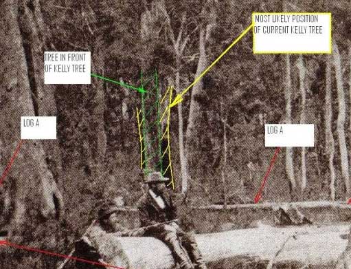
click this link to get full size picture
http://i56.tinypic.com/2qbujxt.jpg
Does anybody have a wide angle picture of the kelly tree area taken
from across the road ? |
|
|
|
Fitzy
Advanced Member
Australia
161
Posts |
Posted - 16/09/2010 : 10:02:11
|
G’day Gang,
Does anyone know if there is an official interpretation/explanation of
the Burman photos? As they were taken as evidence, there should be
some documentation explaining orientation and whom the figures
represent (especially the one standing), and where the creek is
situated. I’ve read many interpretations, though none of historical
fact. Going by McIntyre’s many versions, the standing figure is in the
direction the Kelly Gang advanced from. He also states that he was
looking “down” the creek for his comrades’ return. As the creek flows
from north to south, Mc.Intyre would have to have been facing north in
the direction the creek flowed. I have been trying to locate such a
document and if it exists (which it should), is proving very elusive
to find.
Fitzy.
|
|
|
|
duncs
Senior Member
Australia
23
Posts |
Posted - 16/09/2010 :
11:33:37
|
Hi,
Does anyone have the facility to blow the Burman photos up to the
point where we can see the buttons on the jackets of the standing or
sitting man? Whilst the standing man has his right arm extended and
the crouching man behind the log is holding the rifle normally,
suggesting that they are both right handed, the buttoning of the
jackets would establish conclusively whether or not these photographs
are printed the right way round. I'm not sure if this has been
investigated previously, but think it would be helpful in orienting
the photographs.
Cheers,
duncs |
|
|
|
robert mcgarrigle
Advanced Member
Australia
116
Posts |
Posted - 16/09/2010 :
12:09:03
|
Fitzy ,unfortunately when I
visited the 2 fireplaces I didn't try and find where the creek was
located. I wish to blazes I did but we will all find out in October. I
am sure other members on the forum will know where it is located. I
would like to throw out another question to all members. I believe the
2 Burman photos show that the slope shown actually meets and rises
from the flat piece of ground in the forefront of the photos. Between
the 2 burnt posts it shows 3 or 4 trunks of trees which seem to be at
the end of the clearing and at the beginning of the slope. I also
believe that the log facing east and west nearly reaches the end of
the slope.
Max and others say that the tree is 23 yards from the creek and I do
not doubt that and his preferred site is slightly south of the tree
and a bit more west towards the road. I believe that if you take a
photo from that position in my opinion the slope would be too far away
and that you would have to go down towards the creek and up the other
side to reach the slope. The Burman Photos just do not show that fact
and that is just my opinion in arguing my case. At the 2 huts site
there is a slope rising from the flat piece of ground but as I said
previously am unsure of the creek, it would probably be to the left. |
|
|
|
Glenn Standing
Senior Member
Australia
31
Posts |
Posted - 16/09/2010 : 14:14:28
|
Hi Duncs,
I have been using some blown up prints of the images. For what it is
worth the buttons on the vest of standing man are on his left side.
The same man also carries a revolver on his left side.
Cheers,
Glenn
|
|
|
|
Fitzy
Advanced Member
Australia
161
Posts |
Posted - 16/09/2010 : 17:51:50
|
G’day Duncs,
You’ve raised a good question.
Glenn, I’m not sure what you mean. The buttons on the standing man are
on the left side, but if his vest was open, the buttons would be on
his right and button holes on his left, meaning the photo has not been
reversed. Is this what you mean? That is the way I see it and if you
look at the close-up photo just above these postings, the bloke
sitting on the log also appears to be buttoned up the same way, going
by the creases in his clothing. My opinion is the photo is correct and
has not been reversed.
Fitzy.
|
|

