|
bill
New Member
|
Post by bill on Mar 8, 2014 at 6:57pm
Dee,
The place where Kelvyn and Glenn stand ANYone would pitch a
tent.
Perhaps before the road went through the flat area may have been
a little further back as there is road fill that has intruded
the flat area, and over the past 60 years there may have been a
bit of road bank run off to cause a slightly unlevel surface,
but where they stand is flat enough to pitch a tent.
There are some who say the area at the two huts is not big
enough.
On page 7 - 3 March on this thread I demonstrated to Poorflower
that the Burman photo camera was only 50 cm above the ground to
take in the footprint of the hut site shown with Kelvyn and
Glenn Standing at the tent. If anyone wishes to, take a picture
of your back yard from head height and then one at knee height.
You will soon see the knee height picture looks like you have a
gigantic back yard, yet walk into it with your eyes open and you
say- Oh its not as big as I thought. That’s exactly what these
neigh Sayers need to appreciate. I can't put it simpler than
that.
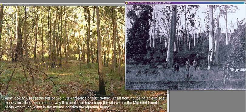
I will show you a picture of the two huts
site taken from the road slightly looking down - compared to the
photo in the Beautiful Mansfield booklet circa -1897* to 1906.
The B&W booklet was in print for 9 years or 18 years after the
event. Going by the mounds seen, I believe the Mansfield photo
was taken at the two huts site looking east but stand to be
corrected. * I have photocopy dated.
Bill
www.ironicon.com.au/images/twohutsmansfieldscene.jpg

PS, Brain, who you say you
are, my hand is extended to you. When do we meet at SBC ?
You tell me. I have never been impressed with your biased views
as posted if you were the honourable person you say you are, as
then you would never attack me for my convictions as you keep
doing. I was always interested to meet you being a stone mason
as I remember you telling us years ago. As you know I am
interested in architecture too. Brian, life is too short, keep
an open mind. Why not give me a ring.
For full size image -
www.ironicon.com.au/images/twohutsmansfieldscene.jpg |
|
|
|
|
Glenn
Guest

|
Post by Guest on Mar 8, 2014 at 8:11pm
Hi Bill,
I still maintain that the hut location above is now shown on the
opposite side of the fireplace to this image.
www.ironicon.com.au/images/twohutssouthslopefromroad.jpg

In addition the tent location you now indicate does not match
your conclusions and can only repeat what I wrote previously.
Within the findings and conclusions -Stringybark Creek The
Authentic Location
From page 29
Quote: 2. “That the police tent was pitched on the rise slightly
West of the road with a commanding view overlooking the numerous
logs that the police had used as a beacon bon fire far enough
from the tent.” Unquote
This would place the tent on the far side of SBC road. So the
location shown above does not match the conclusions.
Quote: 3. “That the police tent was pitched behind a ruined hut
but one still standing maybe slanted over and dilapidated ready
to fall “ Unquote
Please correct me if you think I am mistaken but the hut behind
which you show the tent pitched above (Hut X) was Broomfield's
hut - the one (2 Burnt posts in the Burman image) burnt down 15
months prior to the event.
The fireplace stones of which you have said can be seen
scattered near the standing mans feet in the Burman image.
|
| |
|
|
Horrie
Guest
|
Post by Guest on Mar 8, 2014 at 10:15pm
Bill, I found your Java
moving panorama (on another site) illuminating. Among other
things, it showed the two hut posts drawn in.
Glenn, I'm struggling with your posts. Above, you say "This
would place the tent on the far side of SBC road. So the
location shown above does not match the conclusions"
Imprecise statements like "far side of the SBC road" have got me
scratching my head - and how can we find what conclusions don't
match what?
|
| |
|
|
Glenn
Guest
|
Post by Guest on Mar 8, 2014 at 10:59pm
Hello Horrie,
Have you fully and carefully read the findings and conclusions
within -Stringybark Creek The Authentic Location?
It can be difficult to follow but by making notes of all that is
mentioned about huts, which hut is which and who built them is
to put it politely - very confusing. (Re my 2nd post. Page 1.
Feb. 18)
Then compare them to the diagrams shown.
The tent location illustrated above (P 10) has the tent some
distance further down on the Eastern side (creek side) of SBC
road. West side of the road is above the road (On the far side
of road) The road is directly behind the tent location within
the image some distance further back out of view.
There is good reason why I am pursuing this subject. So please
don't take it as me nit picking.
Re the SBC forum. I did successfully try to view this forum on
another computer. I am surprised and sorry that you are unable
to view this subject. |
| |
|
|
Horrie
Guest
|
Post by Guest on Mar 8, 2014 at 11:37pm
Nobody has mentioned the famous, invented
brand-new leather body straps claimed by Ian Jones to have been
taken by the police party to SBC.
There was no sign of them when the bodies of Lonigan and Scanlan
were recovered. Their 10 x 8 foot tent and bedclothes had been
burnt, and their pockets turned out. But no leather body straps.
Glenn, my view is that most of the discussion about the huts is
guesswork. At Bill's site, they were gone when Burman took his
photos. On his site, Bill discovered fireplaces of two huts and
evidence of post holes. Who erected them and when is kind of
superfluous when they were all but gone when the Mansfield
Police Murders took place. |
| |
|
|
Horrie
Guest
|
Post by Guest on Mar 9, 2014 at 12:15am
Glenn, I've gone back to your post. Thank
you for being polite and cordial.
My better-half thinks I have a very extravagent and expensive
Kelly library. It includes a numbered copy of the Police Royal
Commission facsimile edition which cost hundreds two decades
ago. However, the online material has got me stuffed. You do
confuse me when mentioning online publications without
citations. You are familiar with all this material. I am not. I
guess this is why I wish you CSI guys could post easily
digestible illustrative stuff so I can see at a glance what you
are saying.
Good Night! |
| |
|
|
Glenn
Guest
|
Post by Guest on Mar 9, 2014 at 10:21am
Hi Bill,
Re pic above.
Within -Stringybark Creek The Authentic Location Page 25
Quote : "Image right, this scene was taken across what is now
the picnic ground looking east from a 1897 booklet ‘Beautiful
Mansfield’ photo title “Police Camp, Wombat Ranges. Scene of
Kelly Outrage” [10]
GLENN refers to this image below
I find it interesting that you have now changed your view on
this?
|
| |
|
|
Dee
Administrator


|
Post by Dee on Mar 9, 2014 at 2:28pm
Horrie I
think the "leather straps" deserves a thread of its own. Ive
been thinking of writing something about that after watching the
Sunrise Interview with Derryn Hinch and a Kelly Sympathiser who
mentioned them in his restatement of the so called "self defence
argument". |
| |
|
|
bill
New Member
|
Post by bill on Mar 9, 2014 at 2:48pm
Glenn,
Regarding the composite Mansfield and Huts site picture
You wrote;
Hi Bill, I still maintain that the hut location above
is now shown on the opposite side of the fireplace to this
image.
In addition the tent location you now indicate does not match
your conclusions and can only repeat what I wrote previously.
You then refer point 2 below from
my document-
Quote: 2. from Page 29 ,
That the police tent was pitched on the rise slightly west of
the road, with a commanding view overlooking the numerous logs
that the police had used as a beacon bon fire far enough from
the tent.
Yes Glenn this is in error, I never corrected this and is my
oversight, thanks.
I think this scenario was due to my acceptance the tent was
pitched 70 yards from the creek, hence it could only have been
way over the road to the west, and much the same problem you
have down near your Kelly tree site. Linton had the tent pitched
about 7-8 metres west of the road bank, that you later moved the
tent onto the road position.
In
addition, I admit I have made another error you pointed out
where I had marked the first fireplace (from the road with an X
too far north). However, careful examination of the original
images revealed the fireplaces either side of the figure. I have
also lined in the foot print where the tent may have been
pitched.
See amended image-
www.ironicon.com.au/images/twohutssouthslopefromroad.jpg
Then, you refer to Quote 3, page 29 from my document-
" That the police tent was pitched behind a ruined hut but one
still standing maybe slanted over and dilapidated ready to fall,
and that north of the logs there had been another hut that was
burnt down as was reported in the press of the time."
Glenn, I can turn it around and
around as you wish, but all we know is 'they pitched their tent
near the ruins of two small huts'. Also they pitched the tent
behind an old hut. Whether it was completely ruined or just
ruined who knows.
If the hut north of the logs ( to which you refer) was more
ruined than the other or visa versa does it make any difference
? Not really. All we are interested in is identifying the
correct site where the police had camped and where the police
were shot.
In your last posting,
Page 25 of my document;
Quote : "Image right, this scene was taken across what is now
the picnic ground looking east from a 1897 booklet ‘Beautiful
Mansfield’ photo title “Police Camp, Wombat Ranges. Scene of
Kelly Outrage” [10]
Yes, that above quote may well be
correct, and it may also have also been taken at the two huts ?
I did say " I stand to be corrected" -
And the text imbedded in the image reads,
Quote " Apart from not being able to see the skyline, there is
no reason why this ( photo) could not have been the site where
the Mansfield booklet photo was taken. What is the mound besides
the squatting figure? "
I may have changed my mind as you
infer, its simply there are several locations where this photo
could have been taken. Just because I wrote (as you quote) that
the photo was taken across what is today's picnic ground does
not mean it has to be there, (and I may change the text for this
in my document) but it could well have been taken there
considering the conflicting Parish plans of 1884 and 1885, each
with a different location 'Where the police were shot by the
Kelly's'. As before mentioned on another page of this forum,
these two sites are 160 metres apart. (not counting the two huts
site which is ANOTHER 200 m up the creek)
Glenn, in your teams CSI@SBC the Report, on page 62 - 64 there
are images of those two parish plans 1884 and 1885. The CSI team
has blindly accepted these two parish plans showing the same
locations yet they are 160 metres apart? How can your CSI report
not make mention of this discrepancy? -Especially IF you had
engaged 'Absolute Surveying Pty Ltd' to help you all put
together a trustworthy document. All the CSI report says is that
these maps confirm the camp site was on the western bank of the
creek. Even McIntyre said that siting on that log with Kelly on
his right being on the creek side while they faced north, etc. No
issue.
I am not even a surveyor but from the blown up images of the
maps courtesy of Sheila and Fay,
www.ironicon.com.au/validlinks.htm I was able to calculate
from the original surveyors notes the discrepancy. It was all
simple arithmetic, yet none of your group bothered to question
these discrepancies because apparently ' it did not suit your
blind faith in Linton's location'. If it does not help the cause
- then don't mention it. That's the motto for the CSI teams
report. This is very sloppy research indeed and the reason why
the CSI team can't show you much of their site, because there is
nothing they can hang their hat on.
Readers should be made aware, it
was I, using the poor photocopy of that first map of 1884,
noting a hut site with 'Police shot by the Kellys' on it. Using
the scale off the map, I was able to plot this hut site on the
ground with nothing more than my car Speedo. I marked a tree at
804 metres from the junction of SBC and Ryans creeks. The CSI
team engaged surveyors and got 802.2 metres. But was there ever
a hut there? Not by my metal detecting the site back in 1985 and
again in 2003.
So, what about the two huts site? Right from the start of land
occupancy the original surveyor was only plotting creeks, hills
rivers, no fence lines or roads because there weren't any, and
he must have just pencilled in a little sqr marked 'hut'
somewhere along the named creek with a notation 'Police Killed
By the Kellys'. Maybe there was an old 1890s miners humpy there
that has left no conclusive trace there today?
When the first land owner took up the lease of about 300 acres
lines were drawn on that first map, now showing the marked hut,
but there was no hut there. Then a year later he complained to
the lands department about having to clear goldmining areas, and
he had another survey done, this time the next surveyor marked
another site 160 m further North. Why would he do that if the
other (804m mark) had a hut on it? It all goes to show the land
owner must have wanted to have notoriety having the Kelly
/police encounter on their land, while all along the real camp
site lay within the undergrowth some 200 m further south on
crown land outside the southern boundary.
All this can be read in my document
www.ironicon.com.au/stringybark_ck_the_authentic_location.pdf
And Glenn, yes I will make those corrections and thank you for
pointing those out.
Bill
|
|
Last Edit: Mar
9, 2014 at 3:44pm by
bill: Just typos and the and that |
|
|
Horrie
Guest
|
Post by Guest on Mar 9, 2014 at 3:27pm
Dee, yes a 'Leather Straps' thread would be
great. They were never heard of again. I missed the Sunrise
segment, but it is surprising how often they keep popping up
condemning the police at SBC.
While looking up something else, I came across a 2012 article
about the MacFarlane book and quoting CSI member Gary Dean. We
haven't heard from him yet in this Forum:
"The archival documents he [Mr McFarlane] read are mostly police
reports, which would obviously be biased, he says.
"Mr Dean says some documents referred to in the book were
'dubious'. "You have to study all the sources, including
newspapers, magazines, letters, unpublished manuscripts, books
and, most importantly, oral history.
It struck me as strange then, and still does today, how much
Gary Dean knew about the 'dubious' sources for MacFarlane's book
- which had not yet been published.
I very much doubt Mr Dean would have been given an advance copy. |
| |
|
|
Glenn
Guest
|
Post by Guest on Mar 9, 2014 at 4:28pm
Bill,
Thank you for your in depth reply. Appreciate it. |
| |
|
|
Glenn
Guest
|
Post by Guest on Mar 9, 2014 at 5:35pm
A few words
from Thomas McIntyre.
During the Beechworth preliminary trial of Ned Kelly. Amongst
the descriptions etc to Mr Gaunston. McIntyre says the
following:
"I don’t think I told a reporter that Scanlon was shot when
making for a tree,
I was annoyed at the reporters – they would suggest questions to
me and take anything for an answer.
I thought too much was published too about the whole matter, too
much was published of his (Kelly’s) deeds. There was too much
published injurious to a fair trial of these men.”
11th August 1880. Thomas McIntyre completes a 46 page statement
before W.Foster P.M.
Part of which reads:
"Within a few days after arriving at the Richmond depot. I made
written notes of everything that I could recollect. ………. I kept
those notes and did not send a written statement to any one till
after the arrest of the accused”
Thomas McIntyre would later recall that:
Kelly on his removal from the court expressed his surprise at
the completeness of my evidence but qualified this remark
immediately afterwards by stating “But the – has had nothing
else to think about during the last two years”
In the events like those described in my evidence, however, I
think that minds of most men are abnormally keen and the
incidents connected therewith get indelibly photographed upon
the brain. |
| |
|
|
Dee
Administrator

|
Post by Dee on Mar 9, 2014 at 6:15pm
Glenn those are incredibly interesting
posts.
McIntyre is often ridiculed and called a liar because of
variations in his accounts but that first two quotes you post
shows he was concerned that the gang got a fair trial , quite a
remarkable thing given how close he came to being murdered by
them. The trouble he had with the Media is no different today!
The third quote is also interesting because it reflects what
most of us still believe, that events get burned indelibly and
accurately into our memories, and memory can be relied on. In
fact what modern research has shown, and its fascinating stuff -
to me anyway - is that memory is very plastic, is remodelled by
emotion at the time such as fear, and by subsequent events
including interrogations where innocent questions can introduce
ideas that might later be incorporated in the memory which can
then end up being completely wrong even when sincerely believed.
I am sure this phenomenon accounts for any discrepancies people
may wish to find between his various statements, and there is no
need to ascribe them to something sinister on McIntyre's part.
Thanks for posting those thought provoking quotes - please put a
few more up! |
| |
|
|
Glenn
Guest
|
Post by Guest on Mar 10, 2014 at 10:09am
Thomas McIntyre
"Standing at the tent entrance and facing the creek there was
upon the left front a felled tree nearly 4ft in diameter, at the
thickest part.It lay nearly east and west.
About midway this log was joined by another which lay due north
and south and terminated where it joined the other.
These two logs thus formed two right angles, the point of
junction being about 25 yards from the tent."
Re pic. Page 13. Post on the 22/11/2010
www.ironicon.com.au/newforum/sbcnewsandviews10.htm
Re pic. End of page 2. Huts @sbc stringybarkcreek.forumotion.com
|
| |
|
|
Glenn
Guest
|
Post by Guest on Mar 10, 2014 at 10:18am
Bill,
Would you like some time to reposition the tent location on your
scaled map, layouts and diagrams?
If we compare the tent location in the amended image above -
www.ironicon.com.au/images/twohutssouthslopefromroad.jpg to
the scaled map on page 36 within -Stringybark Creek The
Authentic Location
Would I be correct in saying that the positioning the tent tent
would now be located on or just behind the 20 M (mark) left of
the E/W log (4) and fireplace (2) ?
Thanks,
Glenn |
| |
|
|
bill
New Member
|
Post by bill on Mar 10, 2014 at 2:43pm
Glenn,
You propose for me to change my map -
"Would I be correct in
saying that the positioning the tent tent would now be located
on or just behind the 20 M (mark) left of the E/W log (4) and
fireplace (2) ?
The tent location as I have it on the map on my Document page 36
shows the tent by the 3m scale of the grid at around 23 yards or
20 metres. For all intentions, the position fits McIntyre's
description of the East-West log being to the left of the tent
entrance.
Why do you now want me to move the tent position on the map?
On my amended panorama view
www.ironicon.com.au/images/twohutssouthslopefromroad.jpg

You can see where the tent would have been pitched. The
footprint is just a guide for you because you seemed to have
had a problem seeing this location in relationship to the
previously 'incorrect position of the fireplace' now amended.
So why should I make any changes to the tent position?
Remember I had you and Kelvyn standing there.
Thanks,
Bill |
|
Last Edit: Mar
10, 2014 at 7:22pm by
bill: Highlight quote |
|
|
Glenn
Guest
|
Post by Guest on Mar 10, 2014 at 4:00pm
Hi Bill,
Yes, I think it would be best corrected.
Re scaled map Page 36. The tent was previously shown to be in
the South West corner of the clearing (Slope side) facing East.
Now it would be in the North West corner of the clearing. (Non
slope side)
Have no problem with the tent being 23 yards from the fire. (As
before) So the tent can be rotated on an arc to near the 20 M
(mark) left of the E/W log (4) and fireplace (2) facing South
East. (according the scaled map) With the logs in the same
position.
The tent as shown in the amended panorama view
www.ironicon.com.au/images/twohutssouthslopefromroad.jpg
faces towards the South East and the creek. SBC road runs almost
due N/S
This would place the tent on the left of the log and fireplace
according to the scaled map. Can we agree on this?
Thanks,
Glenn |
| |
|
|
Kelvyn
Guest
|
Post by Guest on Mar 10, 2014 at 4:44pm
Geez a couple of days away and then back to
this continuing CRUD and CRAP from DENHELD:
Quote: “Brian you are nothing more than a pseudo for either
Glenn or Kelvyn, We can pick it a mile off.”
IT’S IN CAPitals BILL SO YOU CAN CLEARLY ABSORB THE FOLLOWING:
YOU HAVE TRIED BEFORE TO PICK AND I CAN ASSURE YOU THAT YOU HAVE
MADE A COMPLETE ASS OF YOURSELF EVERYTIME. BRIAN IS NOT REPEAT
NOT ME AND IT IS CERTAINLY NOT GLENN AS HE IS CLEARLY
IDENTIFYING HIMSELF IN HIS MANY EXCELLENT POSTINGS. U
THEN YOU CONTRADICT – AT LEAST HAVE TWO BOB (THATS 20 CENTS IN
TODAY’S SCHECKELS) EACH WAY WITH THE FOLLOW UP
QUOTE: “If you are a real person with an open mind why not just
give me a ring today so we can have a chat”.
TIME YOU GREW UP AND STOPPED WITH YOUR SILLY PSEUDO GAME.
Notice Kelvyn does not mention he was wrong about the tramway
along SBC.
The track he refered to was infact the Bridle track on the
western bank of the creek leading up to the two huts and beyond.
GO GET AND READ EVANS’ RESEARCH MATERIAL AS THAT IS the PRIMARY
SOURCE
The map-
Quote- " the latter two would be included by McIntyre around ten
years later in his very detailed to scale diagram now on
permanent display at the Victoria Police Museum, and reproduced
in both the CSI Team’s report and my book.
YES AN ERROR IN SENTENCE CONSTRUCTION BY ME (NOT A SPELLING
error)
From this an artist produced the sketch shown by W Denheld."
THE CORRECT WORDING SHOULD HAVE BEEN:
From this rough sketch an artist produced the sketch shown by W
Denheld."
Oh boy, this must be the joke of the decade. Kelvyn, I don't
know where you get your information from, perhaps from your own
book?
WHICH I DOUBT YOU WOULD HAVE READ AS IF YOU HAD YOU WOULD HAVE
SEEN THAT YOUR QUESTION IS BASELESS.
that the The" Sydney Mail" sketch shown on my map of SBC - -was
first published on 16 Nov 1878 - just 3 weeks after the event
which makes it Primary Source material- and NOT AT ALL- ten
years after the event as you falsely claim.
TEN YEARS = MCINTYRE’S DETAILED SCALE DIAGRAM WITH LOGS AND TENT
AND POSITION OF THE POLICE AT FOUR SEPARATE MOMENTS IN THE
OVERALL SAGA SO NIT5PICKING ABOUT THE POSITION SHOWN OF THE
POLICE IS AGAIN YET ANOTHER FEEBLE ATTEMPT TO DEFLECT FROM THE
IMPORTANCE OF THIS DETAILED DIAGRAM. WE TRIED TO ‘EXPLAIN’ THAT
THE DIAGRAM ONLY GIVES FOUR-MOMENTS- IN- TIME TO YOU BUT AS WAS
THE CASE IT WENT THROUGH TO THE KEEPER.
Quote “The CSI@SBC report does not even show this 'Sydney Mail
sketch' or the SBC wide scene in the 'Australasian Sketcher', or
the 'News Illustrated front cover', why not ? Because it does
not help their cause for the Kelly tree site.
What is the value of a SBC report that excludes important
Primary Source sketch material drawn at that time when state of
the art photogrphic cameras were only just beginning to replace
the artists work. Sketches had to be an accurate depiction of
any scene”.
OH GET OVER IT BILL: THE TEAM DID NOT PLACE ANY ARTIST
IMPRESSION INTO THE REPORT AS IMPRESSIONS ARE NOT SUBSTANTIVE
(NOR PRIMARY AS YOU WANT SUCH MATERIAL TO BE CONSIDERED AS)
EVIDENCE – THE TEAM DID HOWEVER INCLUDE ALL CURRENTLY KNOWN
PHOTOGRAPHS RELEVANT TO THE INVESTIGATION.
WHAT IS THE AXE, OR IS IT A TOMAHAWK DOING IN THE LOG BILL? YOU
KNOW IT IS CLEARLY SEEN IN THE AUSTRALASIAN SKETCHER ARTIST’S
IMPRESSION.
(NO DOUBT THE ARTISTS’ IMPRESSIONS OF EVENTS SUCH AS THE SINKING
OF THE TITANIC WOULD ALSO MEET YOUR “PRIMARY” CONDITION.)
“Readers, please note this sketch does not sit well with the CSI
Kelly tree scenario.
I will tell you why they want to ignore it,-
1, Because CSI team only want to use McIntyre's base map instead
of a combination of all primary source materials. They blindly
follow Linton Briggs's scenario.
REFER TO ABOVE- THE TEAM HAS UTILISED FAR MORE SUBSTANTIVE
(PRIMARY) MATERIAL THAN YOU WITH YOUR DOGMATIC MYOPIC APPROACH
TO INVESTIGATING AND NOT ACCEPTING IRREFUTABLE SUBSTANTIVE
EVIDENCE.
2, They want the Burman photo to be looking North East -FROM
near the Tent in the Sydney Mail sketch, yet the sketch' clearly
shows the direction the Kellys are shooting the police - to the
North, and from where the police came back to camp, this
orientates the sketch. The view of the sketch is looking WEST.
WE DON’T WANT ANYTHING BILL OUR WORK STANDS WITHOUT A ‘WANT’ AND
IT IS YOU WHO SEEM TO ‘WANT DESPERATELY’ TO HAVE YOUR POSITION
VALIDATED BUT YOU CANNOT CONVINCE MANY (MANY) PEOPLE TO YOUR
VIEW.
So why would you now want me to make any changes to the tent
position,
Remember I had you and Kelvyn standing there.
SO WHAT , I WILL OBLIGE ANY ONE WHO ASKS ME TO POSE FOR A CAMERA
SHOT. I THINK I SENSE A PATHETIC ATTEMPT BY YOU TO CO-JOIN ME
WITH YOUR VIEWS THUS PROVIDING SOME LEGITIMACY TO YOUR WORK,
I’LL SEND YOU SOME MORE PICS OF ME WITH OTHERS (NOT CSI TEAMERS)
AROUND YOUR AREA WHEN WE WERE MAKING DETAILED ASSESSMENT OF YOUR
ROCK PILES. I’LL BLACK OUT THE FACES THOUGH AS THEY WOULDN’T
LIKE TO FIND THEMSELVES BEING PILLORIED.
For the red liners here are “lastest posting” “ enableing”
“graphicaly” “referres” and again “referres” photogrphic
SCHOOL REPORT: IF THIS IS THE LEVEL OF PRESENTATION THE STUDENT
NEEDS TO CONCENTRATE . PRESENTATION REFLECTS ON THE WRITER’S
WORK OVERALL, NEEDS IMPROVEMENT. |
| |
|
|
bill
New Member

|
Post by bill on Mar 10, 2014 at 7:17pm
Glenn and
Kelvyn,
You are so obsessed with fighting the two huts site while Linton
or Gary are sitting back not saying a word. I have presented my
case again and again, its really now up to you put your case for
the CSI@SBC report.
Bill |
| |
|
|
Horrie
Guest
|
Post by Guest on Mar 10, 2014 at 11:32pm
Totally agree, Bill. Its like 'Waiting for
Godot' who never arrived.
Wake |
|
| |
|
