|
Glenn
Guest |
Post by Guest on Mar 4, 2014 at 10:47pm
There had been a hut on the clearing, but only
remains of it were left standing.
There being the remains of a hut there.
We camped immediately behind the old hut, erecting a tent there.
Where we built the fire was near two logs, about twenty yards
from the tent. |
| |
|
|
Horrie
Guest |
Post by Guest on Mar 4, 2014 at 11:16pm
...and, and, Glenn? What's
your point?
Your Kelly Tree site has been bulldozed often in the past.
You'll need side-looking radar (SLR) to find any hut remains.
You guys have been nit-picking Bills work for so long its
embarrassing.
Bill is right and you all know it! |
| |
|
|
sarah
Junior Member


|
Post by sarah on Mar 5, 2014 at 1:08am
Horrie you really are horrid
and have contributed nothing to this debate as you are the one
that has been nit-picking, especially about spelling and you are
the biggest proponent of misspelling with Bill a close second.
You fail to comprehend the simplest of things and even said
yourself you had to read a post ‘slowly’ to understand it. It
has been simply pointed out to you where the tent and logs were
in relation to the spring (that Bill doesn’t have), and this
spring is described along with the area in detail and you still
don’t get it. This description fits the CSI site not Bill’s.
|
| |
|
|
Horrie
Guest
|
Post by Guest on Mar 5, 2014 at 2:03am
Buzz off Sarah (Fitzy)!
Dee has admonished you frequently for disruptive misbehaviour.
You promised to leave us days ago, but are still here being
silly.
I have never raised the subject of the logs, tent or spring,
other than perhaps in passing. |
| |
|
|
sarah
Junior Member
 |
Post by sarah on Mar 5, 2014 at 9:50am
Again you fail to comprehend
Horrie, Logs, Tent and spring are pinpointing where the police
camp was. You are so negative you do not read posts slowly
enough to be able to comprehend. Either that or you are playing
dumb to be disruptive. If you have no interest in this subject
or do not want to learn, then I suggest you buzz off! |
| |
|
|
Glenn
Guest
|
Post by Guest on Mar 5, 2014 at 9:56am
Within McIntyre’s various
accounts of the hut we read:
at the burnt hut
an old burnt hut
the remains of a hut there
the old hut
but only the remains were left standing
We camped immediately behind the old
hut, erecting our tent there.
Throughout McIntyre mentions hut singular.
G.W.Hall. Author of "The outlaws of the wombat ranges”
The spot where they established their
halt was a small clearing on the rise alongside of the creek,
near the ruins of two small huts, one of which was burnt down,
and had been the residence of three prospectors, named Reynolds,
Broomfield and Lynch …….
One burnt hut, one ruined hut.
J.J. Kenneally in his "Inner History of the Kelly Gang”
Dan was deputed to find out the exactly
where the police were camped. After careful reconnaissance he
returned and reported that the police were at the shingle hut on
Stringybark creek, and that their tent was pitched in
a clear space nearby.
One hut – The burnt hut in the clearing.
One ruined hut nearby the clearing – The shingle hut |
| |
|
|
|
|
Glenn
Guest
|
Post by Guest on Mar 5, 2014 at
11:16am
How can compare
McIntyre’s distances?
From - The Melbourne Herald’s
Special Reporter’s article:
"At the top of the slope and overlooking the police tent, was a
clump of scrub and sword grass, some sixty feet in
circumference, and in which a dozen men could conceal
themselves.
Standing a few feet in front of this clump of scrub but still
overlooking the police tent , are two bunches of sword grass,
four feet six inches high, and presenting a covering surface of
some six feet.
It was from behind these bunches of sword grass that Kelly and
his confederates called on the police to surrender………………
"At the time the call to surrender was made, McIntyre was at the
fire cooking. This was precisely 39 paces from the foremost
bunches of grass.
The tent stood exactly 25 paces from the Kelly’s hiding place”
McIntyre:
There was a quantity of spear
grass 5ft high about 35 yards from the fire on the south side of
the clearing.
There were some tall spear grass at the south side of the open
space. It was about 35 yards from the fire where we were
standing about 5 foot high or quite high enough to hide persons.
Both my revolver and the shot gun were at the tent about 24
yards distant on my right and about the same distance from some
of the attacking party
The four men were in line and two or three yards distant from
each other and all the same distance – about 40 yards
From the fire
McIntyre about 35/40 yards.
Reporter 39 paces
Tent from attacking party
McIntyre about 24 yards
Reporter 25 paces.
Given that it would be highly unlikely that McIntyre paced these
distances himself his estimations of distance are not too bad at
all.
McIntyre also stated that the tent was pitched a few yards
behind the remains of the hut. The burnt hut.
About 20 yards from the fire
The tent being pitched about 70 yards from the creek. |
| |
|
|
Glenn
Guest
|
Post by Guest on Mar 5, 2014 at
12:30pm
Quote:
"Isn't it amazing how these people now
want to diminish the Two Huts site while the CSI team are still
unable to provide even the slightest evidence of their location
near the Kelly tree, -
except for some text and swamp gums, what ever they have to do
with it I have no idea,"
From - The Melbourne Herald’s Special
Reporter’s article:
"At the top of the slope and
overlooking the police tent, was a clump of scrub and sword
grass, some sixty feet in circumference, and in which a dozen
men could conceal themselves.
Sword grass (Gahnia sieberiana) – or the
“spear grass” grows in specific areas.
Swamp gums also only grow in specific areas.
Both can sustain periods of dryness but prefer moist, or wet
areas.
Both abundantly grow at the site of the spring and declivity in
the location near the Kelly tree. Near the white hill.
The spear grasses mention by both McIntyre and the special
reporter.
Approx. 25 yards from the tent location within the CSI report.
With the tent being place exactly 70 yards from the creek.
(McIntyre about 70 yards) Facing due East.
Special reporter mentioned the tent faced North.
Therefore it could also be said that the tent faced N/E. Both
cases share the similar results.
Tent from attacking party
McIntyre about 24 yards
Reporter 25 paces |
| |
|
|
Glenn
Guest
|
Post by Guest on Mar 5, 2014 at 1:27pm
How can we confirm the tent was located
behind the burnt hut?
Using Bill’s scaled log layout draw a hut approx. 20ft long in
both directions. Incorporating the two burnt posts.
One to the right towards Bill’s fireplace location.
The other towards the viewer of the Burman images (McIntyre’s
tent position in his diagram)
Then draw a circle 20yrds and 25yards from where the two logs
meet. From the fire (McIntyre provided both approx. tent to fire
distances)
Place the tent a few yards (Up to 5yrds) behind each hut. (A dot
will do)
See for yourself which position best matches McIntyre’s diagram
and descriptions.
Combined with the Burman images a very good match.
McIntyre:
"We made a fire about 20 yards from the
tent where the two logs crossed each other"
"These two logs thus formed two right angles, the point of
junction about 25 yards from the tent" |
|
|
|
And me yet
again
Guest ( Kelvyn )
|
Post by Guest on Mar 5, 2014 at 4:22pm
Horrie, I have no doubt that you simply
cannot digest FACTS of which you should by now have been able to
read throughout recent postings by me and now also by Glenn.
" Your Kelly Tree site has been
bulldozed often in the past. You'll need side-looking radar (SLR)
to find any hut remains"
So now it is imperative to address you in CAPS so you also get
it through your ??
THE EASTERN SIDE OF THE ROAD RESERVE HAS NEVER BEEN BULLDOZED -
PROVABLE BY BEING ABLE TO LOCATE THE REMAINS OF A SIGNIFICANT
TRAMWAY THAT PROGRESSED ALONG THIS SIDE BETWEEN THE ROAD RESERVE
AND THE CREEK AND STILL THE REMAINING SHAFTS USED BY THE MINERS,
AND ALSO WATER RACES.
I DID POINT OUT IN AN EARLIER POSTING THAT THE WESTERN SIDE OF
THE ROAD WAS EXTENSIVELY BULLDOZED FOR A FIRE BREAK SOME FEW
YEARS AGO.
IT SEEMS YOU ARE HALLENGED BY BEING UNABLE TO ASCERTAIN THE EAST
FROM THE WEST.
AND THE CSI TEAM HAS NEVER REFERRED TO THE LOCATION OF THE
POLICE CAMP AS THE KELLY TREE SITE WHICH YOU FLOG AS BEING A
TRUTH ! STOP ACTING LIKE A FOOL.
OH, AND I REPEAT - READ THE REPORT (OR ARE YOU TOO LOUSY TO
SPEND MONEY/) REMEMBER ITS FREE TO LOOK AT FROM THE STATE
LIBRARY VICTORIA OR TAKE A JAUNT TO CANBERRA AND THE NATIONAL
LIBRARY.
PS AND SO YOU DON'T GET YOURSELF FURTHER CONFUSED - I DON'T MEAN
THOSE BIG LOUD TRAMS THAT RUN AROUND IN MELBOURNE!!
(Above text can be read and absorbed by most people in just a
few minutes - take as long as you must however) |
| |
|
|
Horrie
Guest
|
Post by Guest on Mar 5, 2014 at 8:39pm
Glenn thank god you are a
man of few words, and well-connected thoughts and superb
presentational skills!
OK I jest! Glenn, you and your shy pal 'Me' are very
long-winded, and have the habit of a lot of pro-Kelly people of
putting words in other people's mouths which they didn't say.
Some of the points you make are spurious -
"I DON'T MEAN THOSE BIG LOUD TRAMS THAT RUN AROUND IN
MELBOURNE!!" So you must mean a logging tramway (and you
must know tramway expert and author Norm Houghton). Why didn't
you say so?
All the CSI team have to provide here is a sketch of the
location of their preferred site.
But all we have been given is a parade of excuses why you can't
do so.
I'm beginning to think this is all 'Kill Bill', and no CSI Site
presentation. Oh well, another disappointment. |
| |
|
|
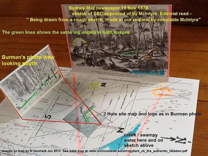
Glenn
Guest |
Post by Guest on Mar 5, 2014 at 9:59pm
Horrie,
Short reply.
Please refer to the stringy bark creek forum.
Orientation of the Burman images. Page 2. Mid way down is the
CSI diagram showing the location of the site |
| |
|
|
Horrie
Guest
|
Post by Guest on Mar 5, 2014 at 11:18pm
I've spent the whole evening seeing
how Ian Jones triumphed over Bill and CSI in getting his wacky
site approved by DSE officials who were easily fooled.
The Kelly Tree Reserve today is a shambles.
The CSI site (or, rather, the Linton Briggs site) was presented
by CSI in 2009:
www.ironicon.com.au/stringybarkckinvestigation.htm
Ian Jones's site is shown with a purple triangle; Linton
Briggs's (CSI) by green triangles and Bill's Two Huts site by
yellow triangles.
Don't ask me why the triangles. The amateur sleuths from CSI
never explained what they meant.
So... I have had to do what CSI today can't do - provide an
illustration of their site!
 |
| |
|
|
|
|
Horrie
Guest
|
Post by Guest on Mar 6, 2014 at 12:41am
Dee, you must visit SBC
yourself. As you forecast, the whole locality will be deeply
moving.
But if you go with Bill to his Two Huts site and see him hold up
the big Burman photo towards the road, you will gasp with shock
at how the scenes match perfectly.
You will discover Bill is a quiet Ned supporter. It will trouble
you thinking about everything later, why a small handful of
people have spent six years back-stabbing him for his thousands
of research hours in rain and scorching suns, and patient
presentations.
Why is his Two Huts site so disturbing to the Ned Neanderthals?
Why have former mates like the CSI geriatric chumps turned
against him? Why do useless time-wasters like Pooflower and
Sarah attack him relentlessly. Many of Bill's noisiest critics
have never been to the Two Huts site.
|
| |
|
|
Horrie
Guest
|
Post by Guest on Mar 6, 2014 at 1:53am
I see the triangles in the
2009 CSI presentation are photo views. What photos are these?
If, in relation to Bill's Two Huts site, they are the Burman
photos, they are showing the wrong direction. Misleading
information always is nearly impossible to undo. |
| |
|
|
Glenn
Guest
|
Post by Guest on Mar 6, 2014 at 8:01am
How is it that the yellow triangle's (Photo
views) 2A & 2B face S/E and SSE when you say the if you hold the
Burman photo towards the road which is SW or WSW ?
As you say " Misleading information always is nearly impossible
to undo."
The triangles above is Bill's work and nothing to do with the
CSI team.
|
| |
|
|
bill
New Member

|
Post by bill on Mar 6, 2014 at 11:00am
Thank you Horrie,
The Stringy Bark Creek Investigation webpage started out as the
vehicle for the team's findings back in July 2009. The sites map
with the 'triangles' was drawn by me.
Each triangle 'array' represents the apex where the BURMAN
camera would have to been if we reckon that was where he took
the photos. The final photo view would be seen from the apex
looking out towards the open fan array.
Further notes about the map's coloured arrays are explained in
detail see -
www.ironicon.com.au/stringybarkckinvestigation.htm
On the webpage - with the map it says
'
The fan
shaped angles represent the Burman photo views.
I know it can be confusing but every photo has four sides just
as looking through a rectangular funnel from the narrow end -
look through the funnel and we see a bottom, a top, and two
sides. The two sides are the lines you call a triangle. Hope
that clears that up.
It is interesting since I drew this map, 3B was the CSI teams
photo view, but they have now turned 3B to be looking towards
North to take in the Kelly tree.
This to me is the most absurd thing as the original Kelly tree
was cut down in 1908, and it was situated well behind
photographer Burman when he took the photos where Const Lonigan
was shot. The Kelly tree as it was known then was where Const
Scanlan fell and died. This was about 40m down the creek from
the two huts site.
Array 2B was considered as a big contender in the early days of
the investigation with Glenn, Kelvyn and Linton, but it could
not have been because there is the creek between the slope and
the logs.
I always favoured Array 2A because there is a slope, there are
two huts fireplaces, McIntyre said he took off on Kennedy's
horse crossing the creek* headed in a northerly direction.
Bill
* Constable James followed horse tracks across the swampy ground
in a northerly direction just as McIntyre said. These horse
tracks were followed by Sgnt Kennedy on foot and was killed on
the Eastern side of SBC.
|
|
Last Edit: Mar
6, 2014 at 11:12am by
bill: Typos |
|
|
bill
New Member
|
Post by bill on Mar 6, 2014 at 12:02pm
Glenn and Kelvyn,
You keep posting a lot of irrelevant stuff but then Glenn does
mention a crucial bit of information the reporter wrote for the
Herald of 6 Nov 1878.
The reporter wrote -
"at the top of the
slope
and overlooking the police tent"
He was obviously there LOOKING down - overlooking the police
tent from the little hill.
Readers, please read what the reporter wrote, this is page 37
from my document.
www.ironicon.com.au/images/SBC37.jpg This is a jpg
image click on link to see full size

Then open map page to see the relevant point numbers in red.
www.ironicon.com.au/images/SBC36.jpg This is a jpg image of
the page but click on link to see full size
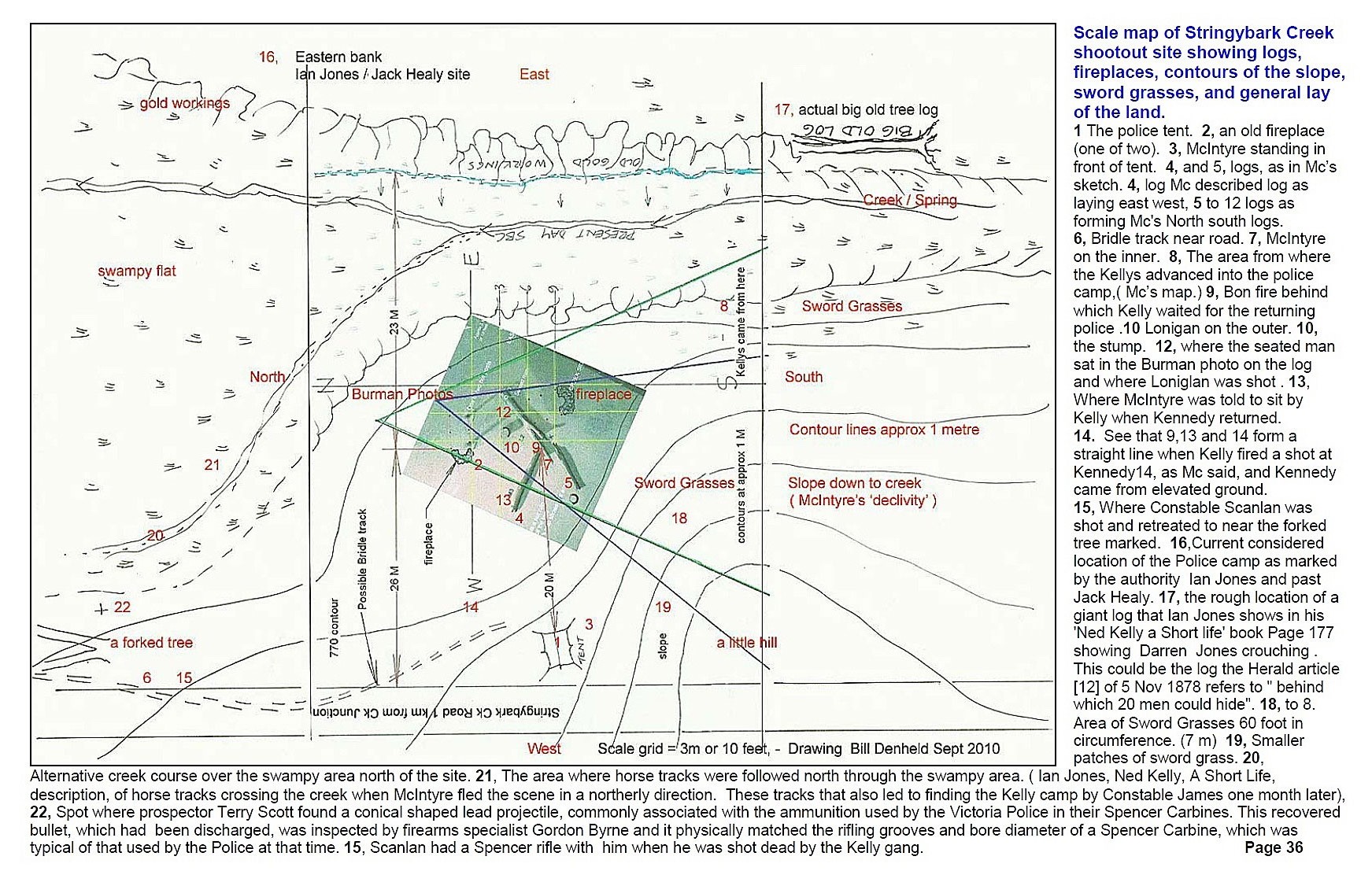
Glenn and Kelvyn,
I cannot believe you keep on with this nonsense because there is
no slope near to your CSI at SBC - Kelly tree location from
which a reporter could take a view over where a tent may have
stood ?
If you think
there is, then PLEASE show us your picture?
Readers, you need go no further to
see the slope /little hill the reporter looked down from
-looking down onto the police tent.
www.ironicon.com.au/images/twohutssouthslopefromroad.jpg

My observation is, these CSI gents are just having us all on,
they know they can't show you a picture or a slope, they have no
hut sites, they have their Burman photo facing the wrong way,
they only seem to have a lots of time.
Also, Glenn invites readers to the SBC forum but it's still a
closed shop where they use the same spin - feet- yards and paces
this way and that from their starting point see image below.
www.ironicon.com.au/twohuts/images/northviewnearkellytreesite.jpg
Please click on link to see full-size image

Now readers please understand, these Gents are standing
where they reckon the police tent stood. They have their backs
to what would have been 'the slope in the Burman photo'. That
new green growth is 1m high, and it was within this vegetation
that Linton Briggs first proposed the police tent had stood. ( 7
metres left /west out from the road) , but 'where is that slope
or little hill' from which a reporter could stand, look and
write - " at the top of the
slope and overlooking the police tent"?
uuuggg, am I wasting my time here?
Bill
PS, Dee, we are not wasting
our time here, only with these CSIs, Poor flours and
confederates. It all reminds me of what poor old Copernicus had
to endure with his proposal the Earth going around the Sun. Poor
old Copernicus had to wait forty years before Galileo was to
prove his theory.
www.ironicon.com.au/images/sbcmappicturessmall.jpg
 |
| |
|
